
North District topographic map
Interactive map
Click on the map to display elevation.
About this map
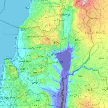
Name: North District topographic map, elevation, terrain.
Location: North District, Israel (32.38710 35.02747 33.33563 35.89502)
Average elevation: 322 m
Minimum elevation: -292 m
Maximum elevation: 2,351 m
Other topographic maps
Click on a map to view its topography, its elevation and its terrain.
Jerusalem
Jerusalem is situated on the southern spur of a plateau in the Judaean Mountains, which include the Mount of Olives (East) and Mount Scopus (North East). The elevation of the Old City is approximately 760 m (2,490 ft). The whole of Jerusalem is surrounded by valleys and dry riverbeds (wadis). The Kidron,…
Average elevation: 661 m
Jerusalem
Jerusalem is situated on the southern spur of a plateau in the Judaean Mountains, which include the Mount of Olives (East) and Mount Scopus (North East). The elevation of the Old City is approximately 760 m (2,490 ft). The whole of Jerusalem is surrounded by valleys and dry riverbeds (wadis). The Kidron,…
Average elevation: 659 m
Tzur Hadassa
Israel > Jerusalem District > Mate Yehuda Regional Council > Tzur Hadassa
Average elevation: 650 m