
South District topographic map
Interactive map
Click on the map to display elevation.
About this map
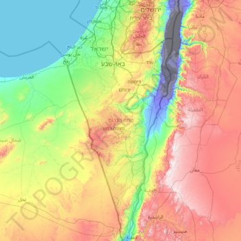
Name: South District topographic map, elevation, terrain.
Location: South District, Israel (29.48779 34.26750 31.87282 35.47601)
Average elevation: 480 m
Minimum elevation: -415 m
Maximum elevation: 1,715 m
Other topographic maps
Click on a map to view its topography, its elevation and its terrain.
Jerusalem
Israel > Jerusalem District > Jerusalem
Jerusalem, Jerusalem District, Israel
Average elevation: 661 m
Tlamim
Israel > South District > Lachish Regional Council
Tlamim, Lachish Regional Council, Ashkelon Subdistrict, South District, Israel
Average elevation: 82 m
Ness Ziona
Ness Ziona, Rehovot Subdistrict, Center District, Israel
Average elevation: 43 m
Jerusalem
Jerusalem, Jerusalem Subdistrict, Jerusalem District, Israel
Average elevation: 659 m
Old City
Israel > Jerusalem District > Jerusalem
Old City, Jerusalem, Jerusalem District, Israel
Average elevation: 749 m
Mt. Hermon
Israel > North District > Golan Regional Council
Mt. Hermon, Golan Regional Council, Golan Heights Subdistrict, North District, Israel
Average elevation: 2,016 m
Tzur Hadassa
Israel > Jerusalem District > Mate Yehuda Regional Council > Tzur Hadassa
Tzur Hadassa, Mate Yehuda Regional Council, Jerusalem Subdistrict, Jerusalem District, Israel
Average elevation: 650 m
Herzliya
Israel > Tel Aviv District > Herzliya
Herzliya, Petah Tikva Subdistrict, Tel Aviv District, Israel
Average elevation: 38 m
Mount Meron
Israel > North District > Merom HaGalil Regional Council
Mount Meron, Merom HaGalil Regional Council, North District, Israel
Average elevation: 943 m
Gezer Regional Council
Israel > Center District > Gezer Regional Council
Gezer Regional Council, Center District, Israel
Average elevation: 111 m