
Western Highlands topographic map
Interactive map
Click on the map to display elevation.
About this map
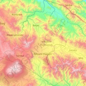
Name: Western Highlands topographic map, elevation, terrain.
Location: Western Highlands, Highlands Region, Papua New Guinea (-6.24445 143.77092 -5.21158 144.52006)
Average elevation: 1,846 m
Minimum elevation: 286 m
Maximum elevation: 4,272 m
Other topographic maps
Click on a map to view its topography, its elevation and its terrain.
Mount Hagen
Papua New Guinea > Western Highlands > Mount Hagen District
Mount Hagen (Tok Pisin: Maun Hagen) is the third largest city in Papua New Guinea, with a population of 46,250. It is the capital of the Western Highlands Province and is located in the large fertile Wahgi Valley in central mainland Papua New Guinea, at an elevation of 1,677 m (5,502 ft).
Average elevation: 1,904 m