
Broadwater County topographic map
Interactive map
Click on the map to display elevation.
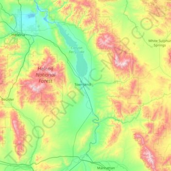
Broadwater County topographic map, elevation, terrain
About this map
Name: Broadwater County topographic map, elevation, terrain.
Location: Broadwater County, Montana, United States (45.83759 -111.78807 46.78178 -111.05418)
Average elevation: 1,602 m
Minimum elevation: 1,110 m
Maximum elevation: 2,892 m
Other topographic maps
Click on a map to view its topography, its elevation and its terrain.
Missoula
United States > Montana > Missoula County
Missoula is located at the western edge of Montana, less than 25 miles (40 km) from the Idaho border as the crow flies. By highway it is 117 miles (188 km) south of Kalispell, 118 miles (190 km) northwest of Butte and 165 miles (266 km) southeast of Coeur d'Alene, Idaho. The city is at an elevation of 3,209…
Average elevation: 1,173 m
Thompson Falls
United States > Montana > Thompson Falls
Thompson Falls is located at 47°35′48″N 115°20′37″W / 47.59667°N 115.34361°W / 47.59667; -115.34361 (47.596587, -115.343730) in the Clark Fork Valley at an elevation of 2,419 feet (737 m).
Average elevation: 782 m
Bozeman
United States > Montana > Gallatin County
Bozeman is located at an elevation of 4,820 feet or 1,470 metres. The Bridger Mountains are to the north-northeast, the Tobacco Root Mountains to the west-south-west, the Big Belt Mountains and Horseshoe Hills to the northwest, the Hyalite Peaks of the northern Gallatin Range to the south and the Spanish Peaks…
Average elevation: 1,495 m