
Thank you for supporting this site ❤️
Make a donation
Make a donation
Bangkal topographic map
Click on the map to display elevation.
Thank you for supporting this site ❤️
Make a donation
Make a donation
About this map
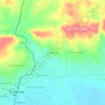
Name: Bangkal topographic map, elevation, terrain.
Location: Bangkal, East Java, 69417, Indonesia (-7.01180 113.85355 -6.97180 113.89355)
Average elevation: 37 m
Minimum elevation: 3 m
Maximum elevation: 97 m
Thank you for supporting this site ❤️
Make a donation
Make a donation
Other topographic maps
Click on a map to view its topography, its elevation and its terrain.
Malang
Indonesia > East Java > Kota Malang
The city was capital city of Singhasari in 1222, then transferred to Dutch colony. Malang was modernized under the Dutch; its mild climate which results from its elevation, along with its proximity to the major port of Surabaya, made it a popular destination for the Dutch and other Europeans. Malang began to…
Average elevation: 490 m
Thank you for supporting this site ❤️
Make a donation
Make a donation
Thank you for supporting this site ❤️
Make a donation
Make a donation