Geolocate

Manila topographic map

Click on the map to display elevation.

Manila

Almost all of Manila sits on top of centuries of prehistoric alluvial deposits built by the waters of the Pasig River and on some land reclaimed from Manila Bay. Manila's land has been altered substantially by human intervention, with considerable land reclamation along the waterfronts since the American colonial times. Some of the city's natural variations in topography have been evened out. As of 2013, Manila had a total area of 42.88 square kilometers.

Wikipedia (CC-BY-SA 3.0)

About this map

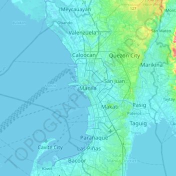
Name: Manila topographic map, elevation, terrain.

Location: Manila, Capital District, Metro Manila, Philippines (14.43063 120.82000 14.75063 121.14000)

Average elevation: 13 m

Minimum elevation: -3 m

Maximum elevation: 220 m

Other topographic maps

Click on a map to view its topography, its elevation and its terrain.

Manila

Philippines > Manila

Almost all of Manila sits on top of centuries of prehistoric alluvial deposits built by the waters of the Pasig River and on some land reclaimed from Manila Bay. Manila's land has been altered substantially by human intervention, with considerable land reclamation along the waterfronts since the American…

Average elevation: 6 m

Leyte

Philippines > Leyte

Mahagnao Volcano Natural Park Located in Burauen, Leyte, about 66 km (41 mi) from Tacloban City, the Mahagnao Volcano Natural Park attracts visitors with its lakes, craters, hot springs, multi-colored mud, virgin forests and lagoon. It was proclaimed as a national park in 1937. Like other regions in the…

Average elevation: 68 m

La Mesa Eco Park

Philippines > Quezon City

Covering an area of 33 hectares (82 acres) the public park is located along the natural boundary of the La Mesa Watershed Reservation and its elevation is about 40 metres (130 ft) below than the resorvoir.

Average elevation: 66 m

Ilocos Norte

Philippines

Average elevation: 260 m

Polangui

Philippines > Albay

known during the early times that the barrio has vas and fertile agricultural land, and because of this, settlers from nearby places migrated to this barrio to venture in agricultural farming. One of the early settlers who migrated to this barrio came from barrio La Medalla, town of Iriga (now a City) of the…

Average elevation: 193 m

La Mesa Eco Park

Philippines > Quezon City

Covering an area of 33 hectares (82 acres) the public park is located along the natural boundary of the La Mesa Watershed Reservation and its elevation is about 40 metres (130 ft) below than the reservoir.

Average elevation: 66 m

Tanauan

Philippines > Batangas

Average elevation: 217 m

Bansalan

Philippines > Davao del Sur

Average elevation: 596 m

Lake Apo

Philippines > Bukidnon > Valencia

Lake Apo is a crater lake in Barangay Guinoyoran in the city of Valencia in Bukidnon province in the Philippines. It is located in a hilly area about 640 metres (2,100 ft) in elevation, about 11 kilometres (6.8 mi) WSW of the city poblacion (town center). Lake Apo was awarded the cleanest inland body of water…

Average elevation: 643 m

Zamboanguita

Philippines > Negros Oriental

Average elevation: 138 m

Barangay 128

Philippines > Manila

Average elevation: 4 m

Sucat

Philippines > Muntinlupa

Average elevation: 11 m

Davao River

Philippines > Bukidnon

Average elevation: 438 m

Pangao

Philippines > Batangas > Lipa

Average elevation: 324 m

Taysan

Philippines > Batangas

Average elevation: 203 m

Barangay 565

Philippines > Manila

Average elevation: 9 m

Daram Island

Philippines > Samar > Daram

Average elevation: 21 m

Magalawa Island

Philippines > Zambales > San Salvador

Average elevation: 1 m

Bucas Grande

Philippines > Surigao Del Norte

Average elevation: 24 m

Ungka

Philippines > Iloilo City

Average elevation: 11 m

Veinte Reales

Philippines > Valenzuela

Average elevation: 6 m

1920

Philippines > Rizal > Taytay

The shape of Taytay is rectangular – trapezoidal with gently hilly rolling terrain on its eastern side while relatively flat on its south-western side, including the poblacion. The municipality's highest elevation ranges from 200 to 255 meters which is situated along the inner north-eastern hills of Barangay…

Average elevation: 49 m

Barangay 700

Philippines > Manila

Average elevation: 6 m

Alitagtag

Philippines > Batangas

Average elevation: 135 m

Odiongan

Philippines > Romblon

Average elevation: 82 m

Bukal

Philippines > Laguna > Cavinti

Average elevation: 312 m

Pandan

Philippines > Antique

Average elevation: 143 m

Barangay 178

Philippines > Caloocan

Average elevation: 83 m

Barangka

Philippines > Marikina

Average elevation: 32 m

Irisan

Philippines > Baguio

Average elevation: 1,322 m

Panaga River

Philippines > Davao del Norte

Average elevation: 266 m

Siasi

Philippines > Sulu

Average elevation: 8 m

Sulop

Philippines > Davao del Sur

Average elevation: 138 m

Parkside 1

Philippines > Quezon City

Average elevation: 22 m

Polillo

Philippines > Quezon

Average elevation: 12 m

Panaon Island

Philippines > Southern Leyte

Average elevation: 61 m

Alangilan

Philippines > Batangas > Batangas City

Average elevation: 51 m

Burias

Philippines > Masbate

Average elevation: 18 m

Bohol

Philippines > Bohol

Average elevation: 77 m

Taguibo

Philippines > Butuan > Anticala

Average elevation: 108 m

Pacijan Island

Philippines > Cebu > San Francisco

Average elevation: 22 m

San Roque

Philippines > Batangas > Santo Tomas

Average elevation: 146 m

Barangay 1

Philippines > Laguna > Calamba

Average elevation: 21 m

Bugsuk

Philippines > Palawan > Balabac

Average elevation: 3 m

Alabat

Philippines > Quezon

Average elevation: 17 m

Saud Beach

Philippines > Ilocos Norte > Pagudpud > Saud

Average elevation: 18 m

Pangil River

Philippines > Laguna > Pangil > Natividad

Average elevation: 292 m

Magdalena

Philippines > Laguna

Average elevation: 65 m

Malabon River

Philippines > Cavite > General Trias

Average elevation: 15 m

Poro

Philippines > Cebu

Average elevation: 12 m

Likas Island

Philippines

West York Island, also known as Likas Island (Filipino: Pulo ng Likas, lit. 'Island of Naturality'; Mandarin Chinese: 西月島/西月岛; pinyin: Xīyuè Dǎo; Vietnamese: đảo Bến Lạc), and several other names. With an area of 18.6 hectares (46 acres), it is the third largest of the naturally…

Average elevation: 0 m

Sibutu

Philippines > Tawi-Tawi

Average elevation: 0 m

Sabina Shoal

Philippines

Average elevation: 0 m

New Washington

Philippines > Aklan

Average elevation: 6 m

Tullahan River

Philippines > Quezon City

Average elevation: 50 m

Palma-Urbano

Philippines > Baguio

Average elevation: 1,448 m

Pangutaran

Philippines > Sulu

Average elevation: 4 m

Lapu-Lapu

Philippines > Davao City

Average elevation: 5 m

Navotas River

Philippines > Navotas

Average elevation: 5 m

San Bartolome

Philippines > Batangas > Santo Tomas

Average elevation: 247 m

Manupali River

Philippines > Bukidnon

Average elevation: 1,036 m

Dalig

Philippines > Rizal > Antipolo

Average elevation: 207 m

Arakan

Philippines > North Cotabato

Average elevation: 523 m

Bagasbas Beach

Philippines > Camarines Norte > Daet > Bagasbas

Average elevation: 1 m

Kota Island

Philippines

Average elevation: 0 m

Tibagan

Philippines > San Juan

Average elevation: 16 m

Lake Pinatubo

Philippines > Zambales

Average elevation: 1,053 m

Lankiam Cay

Philippines

Average elevation: 0 m

Santiago Island

Philippines > Pangasinan > Bolinao

Average elevation: 9 m

Lawak Island

Philippines

Average elevation: 0 m

Pulangi River

Philippines > Bukidnon

Average elevation: 579 m

Lian

Philippines > Batangas

Average elevation: 54 m

Ternate

Philippines > Cavite

Average elevation: 75 m

Milagrosa

Philippines > Laguna > Calamba

Average elevation: 109 m

Zarraga

Philippines > Iloilo

Average elevation: 10 m

Lemery

Philippines > Batangas

Average elevation: 96 m

Tanaytay

Philippines > Pangasinan > Alaminos

Average elevation: 12 m

Santa Catalina

Philippines > Pampanga > San Luis

Average elevation: 6 m

Guimaras Island

Philippines > Guimaras

Average elevation: 28 m

Nabua

Philippines > Camarines Sur

Nabua has about 8,803.0600 hectares or 99.42% very low elevation or less than 100 meters elevation and remaining 51.3593 hectares or 0.58% of low elevation or between 100 and 300 meters elevation. Its slope covers about 7,927.3616 hectares or 89.53% which are level to nearly level (0-3%) while the remaining…

Average elevation: 27 m

Hagonoy

Philippines > Bulacan

Average elevation: 1 m

Batan

Philippines > Aklan

Average elevation: 12 m

Talisay

Philippines > Batangas

Average elevation: 128 m

Pallocan West

Philippines > Batangas > Batangas City

Average elevation: 16 m

Kabacan

Philippines > North Cotabato

The landscape is characterized by almost regular landscape of flat terrain. The high mountains and rolling hills leaping close to the river plus the narrow plains have varied topographical features. Other features are moderately sloping and strongly sloping.

Average elevation: 95 m

Aliaga

Philippines > Nueva Ecija

Average elevation: 26 m

San Manuel

Philippines > Tarlac

Average elevation: 26 m

San Jose

Philippines > Tarlac

Average elevation: 186 m

Peñaranda

Philippines > Nueva Ecija

Average elevation: 39 m

Melville

Philippines > Palawan > Balabac

Average elevation: 23 m