
Warren County topographic map
Interactive map
Click on the map to display elevation.
About this map
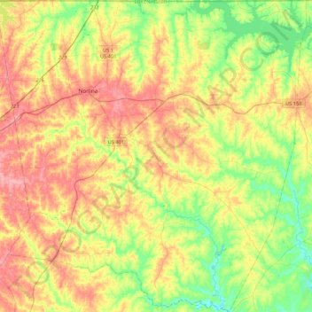
Name: Warren County topographic map, elevation, terrain.
Location: Warren County, North Carolina, United States (36.20252 -78.32388 36.54466 -77.90013)
Average elevation: 94 m
Minimum elevation: 44 m
Maximum elevation: 154 m
Other topographic maps
Click on a map to view its topography, its elevation and its terrain.
Watauga County
United States > North Carolina
Watauga County is extremely mountainous, and all of the county's terrain is located within the Appalachian Mountains range. The highest point in the county is Calloway Peak, the highest peak of Grandfather Mountain (shared with the adjacent counties of Avery and Caldwell), which rises to 5,964 feet (1,818…
Average elevation: 984 m
Charlotte
United States > North Carolina > Mecklenburg County
According to the United States Census Bureau, the city has a total area of 312.00 square miles (808.1 km2), of which 310.02 square miles (802.9 km2) is land and 1.98 square miles (5.1 km2) (0.63%) is water. Charlotte is the twenty-sixth-most expansive city in the United States and lies at an elevation of 751…
Average elevation: 207 m
Wake County
United States > North Carolina
Wake County is located in the northeast central region of North Carolina, where the North American Piedmont and Atlantic Coastal Plain regions meet. This area is known as the "fall line" because it marks the elevation inland at which waterfalls begin to appear in creeks and rivers. As a result, most of Wake…
Average elevation: 96 m
Country Club Estates
United States > North Carolina > Alamance County > Burlington
Average elevation: 195 m
College Acres
United States > North Carolina > New Hanover County > Wilmington
Average elevation: 11 m
Raleigh
United States > North Carolina > Wake County
Raleigh is located in the northeast central region of North Carolina, where the Piedmont and Atlantic coastal plain regions meet. This area is known as the "fall line" because it marks the elevation inland at which waterfalls begin to appear in creeks and rivers. As a result, most of Raleigh features gently…
Average elevation: 103 m
Ocean Isle Beach
United States > North Carolina > Brunswick County > Ocean Isle Beach
Average elevation: 4 m
Winston-Salem
United States > North Carolina > Forsyth County > Winston-Salem
Average elevation: 263 m
Asheville
United States > North Carolina > Buncombe County
Asheville features a climate that borders between a humid subtropical climate (Köppen: Cfa) and an oceanic climate (Trewartha: Do) with noticeably cooler temperatures than the rest of the Piedmont region of the Southeast due to the higher elevation; it is part of USDA Hardiness zone 7a. The area's summers in…
Average elevation: 727 m
Durham
United States > North Carolina > Durham County
Durham is located in the east-central part of the Piedmont region at 35°59′19″N 78°54′26″W / 35.98861°N 78.90722°W / 35.98861; -78.90722 (35.988644, −78.907167). Like much of the region, its topography is generally flat with some rolling hills.
Average elevation: 117 m