
Thank you for supporting this site ❤️
Make a donation
Make a donation
Houston topographic map
Click on the map to display elevation.
Thank you for supporting this site ❤️
Make a donation
Make a donation
About this map
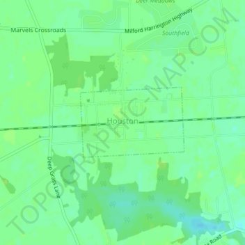
Name: Houston topographic map, elevation, terrain.
Location: Houston, Kent County, Delaware, 19954, United States (38.91354 -75.51121 38.92128 -75.49645)
Average elevation: 15 m
Minimum elevation: 8 m
Maximum elevation: 18 m
Thank you for supporting this site ❤️
Make a donation
Make a donation
Other topographic maps
Click on a map to view its topography, its elevation and its terrain.
Thank you for supporting this site ❤️
Make a donation
Make a donation
Kent Acres
United States > Delaware > Kent County > Kent Acres > Woods Manor East
Average elevation: 8 m
Thank you for supporting this site ❤️
Make a donation
Make a donation
Thank you for supporting this site ❤️
Make a donation
Make a donation