
Make a donation
Kangal topographic map
Click on the map to display elevation.
Make a donation
About this map
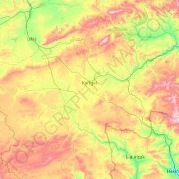
Name: Kangal topographic map, elevation, terrain.
Location: Kangal, Sivas, Central Anatolia Region, 58900, Turkey (38.92536 36.84131 39.48457 37.93201)
Average elevation: 1,660 m
Minimum elevation: 1,091 m
Maximum elevation: 2,666 m
Make a donation
Other topographic maps
Click on a map to view its topography, its elevation and its terrain.
Make a donation
Make a donation
Şanlıurfa
An important consideration in domestic architecture is mahremiyat, which could roughly be translated into English as "privacy" or "intimacy" but which carries stronger implications. This concept is especially important when it comes to relations between men and women – outside the extended family,…
Average elevation: 623 m
Ankara
Ankara has a cold semi-arid climate under the Köppen climate classification (BSk), while under the Trewartha climate classification, the city is classified as humid continental (Dc). Due to its elevation and inland location, Ankara has cold and snowy winters, and hot and dry summers. Rainfall occurs mostly…
Average elevation: 1,082 m
Make a donation
Kayseri
Kayseri sits at the foot of Mount Erciyes (Turkish: Erciyes Dağı), a dormant volcano that reaches an altitude of 3,916 metres (12,848 feet), more than 1,500 metres above the city's mean altitude. It contains a number of historic monuments, particularly from the Seljuk period. Tourists often pass through…
Average elevation: 1,345 m
Make a donation
Devrekani
Turkey > Devrekani > Devrekani
Devrekani is a town and district of the Kastamonu Province in the Black Sea region of Turkey. According to the 2000 census, population of the district is 15,855 of which 6,174 live in the town of Devrekani. The district covers an area of 599 km2 (231 sq mi), and the town lies at an elevation of 1,116 m (3,661…
Average elevation: 1,108 m
Make a donation
Salihli
The city of Salihli, the seat of the district, is located on İzmir-Ankara (E 96) highway and the parallel railway connections. The urban zone is situated on the slopes of Bozdağ mountain chain along the southern alluvial plains of the Gediz River. To the north and northeast of the plain extend two other…
Average elevation: 157 m