
Thank you for supporting this site ❤️
Make a donation
Make a donation
Consett topographic map
Click on the map to display elevation.
Thank you for supporting this site ❤️
Make a donation
Make a donation
About this map
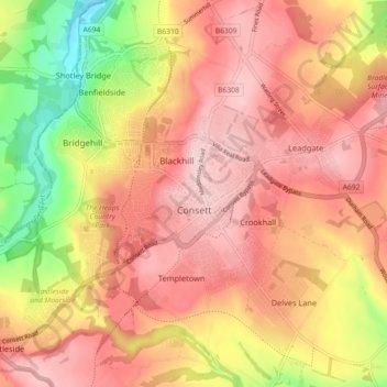
Name: Consett topographic map, elevation, terrain.
Location: Consett, County Durham, North East, England, United Kingdom (54.82807 -1.88241 54.88004 -1.80089)
Average elevation: 205 m
Minimum elevation: 80 m
Maximum elevation: 277 m
Thank you for supporting this site ❤️
Make a donation
Make a donation
Other topographic maps
Click on a map to view its topography, its elevation and its terrain.
College of St Hild and St Bede
United Kingdom > England > County Durham > Durham
Average elevation: 64 m