
Weekley topographic map
Click on the map to display elevation.
About this map
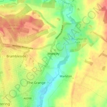
Name: Weekley topographic map, elevation, terrain.
Average elevation: 92 m
Minimum elevation: 61 m
Maximum elevation: 120 m
Other topographic maps
Click on a map to view its topography, its elevation and its terrain.
Barton Seagrave
United Kingdom > England > North Northamptonshire
Other natives of the village include topographer John Bridges and his brother, Charles, a painter.
Average elevation: 78 m
Finedon
United Kingdom > England > North Northamptonshire
The town of Finedon rises to approximately 90 metres Above Ordinance Datum from the River Ise, with the historical centre of the settlement occupying a shallow south-west facing valley. The contemporary point of maximum elevation in the parish is the summit of the disused Sidegate Lane Landfill Site, located…
Average elevation: 75 m