
Make a donation
Montrose County topographic map
Click on the map to display elevation.
Make a donation
About this map
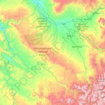
Name: Montrose County topographic map, elevation, terrain.
Location: Montrose County, Colorado, United States (38.15175 -109.06019 38.66855 -107.49892)
Average elevation: 2,307 m
Minimum elevation: 1,394 m
Maximum elevation: 4,333 m
Make a donation
Other topographic maps
Click on a map to view its topography, its elevation and its terrain.
Monument Valley Park
United States > Colorado > El Paso County > Colorado Springs
Average elevation: 1,857 m
Estes Park
United States > Colorado > Larimer County
Estes Park sits at an elevation of 7,522 feet (2,293 m) on the front range of the Rocky Mountains at the eastern entrance of the Rocky Mountain National Park. Its north, south and east extremities border the Roosevelt National Forest. Lumpy Ridge lies immediately north of Estes Park.
Average elevation: 2,429 m
Pikes Peak
United States > Colorado > El Paso County
Soils on Pikes Peak above the timberline (approximately 12,000 ft or 3,700 m) are classified as cirque land. Forests at lower altitudes mostly lie over the brown stony, sandy, loams of the Catamount loam or Ivywild loam series.
Average elevation: 3,902 m
Make a donation
Vail
United States > Colorado > Eagle County
Vail's average elevation is 8,150 feet (2,480 m) above sea level. The town has a total area of 4.5 square miles (12 km2), with no lakes (there is, however, at least one pond). Gore Creek flows from east to west through the center of town.
Average elevation: 2,953 m
Make a donation
Del Norte
United States > Colorado > Rio Grande County
Del Norte's absolute location is at 37°40′44″N 106°21′11″W / 37.67889°N 106.35306°W / 37.67889; -106.35306 (37.679015, -106.352976). Relatively-speaking, it is located where the Rio Grande leaves the San Juan Mountains and enters the San Luis Valley, near its confluences with Pinos Creek…
Average elevation: 2,416 m
Make a donation
Littleton
United States > Colorado > Arapahoe County > Littleton > Littleton
Littleton is located at 39°35′59″N 105°0′39″W / 39.59972°N 105.01083°W / 39.59972; -105.01083 (39.599691, −105.010929) at an elevation of 5,351 feet (1,631 m). Located in central Colorado at the junction of U.S. Route 85 and Colorado State Highway 470, the city is 9 miles (14 km) south…
Average elevation: 1,656 m