
Make a donation
Dolores County topographic map
Click on the map to display elevation.
Make a donation
Dolores County
Dolores County, like other counties in Colorado along its border with Utah, is split into two geographically distinct regions, and in fact, under normal travel conditions, it is necessary to leave the county to travel between the two regions. The western portion of the county (east of the Dolores River Canyon and along the Utah border) is the northern portion of the Great Sage Plain, relatively low (6500–7500 feet in elevation) and flat (but cut by large canyons, including that of the Dolores River itself), and consists of irrigated and dryland farming areas; it is especially well known for the cultivation of various varieties of beans, including pinto beans and many variety of old Anasazi beans. The central portion of the county has higher open grasslands with forested hills, ravines, and canyons, used for livestock raising. The eastern portion of the county is located in the highest peaks of the San Juan Mountains, around the old mining and modern tourist town of Rico, and except for cattle grazing in the San Juan National Forest, has virtually no agriculture, in part because its elevations range from 9,000 to 14,000+. Rico is developing in many ways as a bedroom community for the much wealthier town of Telluride in San Miguel County to the north.
Make a donation
About this map
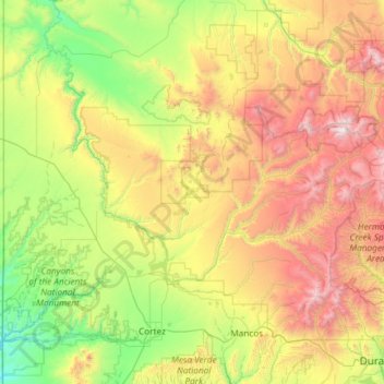
Name: Dolores County topographic map, elevation, terrain.
Location: Dolores County, Colorado, United States (37.48072 -109.04348 37.89640 -107.86155)
Average elevation: 2,385 m
Minimum elevation: 1,473 m
Maximum elevation: 4,265 m
Make a donation
Other topographic maps
Click on a map to view its topography, its elevation and its terrain.
Monument Valley Park
United States > Colorado > El Paso County > Colorado Springs
Average elevation: 1,857 m
Estes Park
United States > Colorado > Larimer County
Estes Park sits at an elevation of 7,522 feet (2,293 m) on the front range of the Rocky Mountains at the eastern entrance of the Rocky Mountain National Park. Its north, south and east extremities border the Roosevelt National Forest. Lumpy Ridge lies immediately north of Estes Park.
Average elevation: 2,429 m
Pikes Peak
United States > Colorado > El Paso County
Soils on Pikes Peak above the timberline (approximately 12,000 ft or 3,700 m) are classified as cirque land. Forests at lower altitudes mostly lie over the brown stony, sandy, loams of the Catamount loam or Ivywild loam series.
Average elevation: 3,902 m
Make a donation
Vail
United States > Colorado > Eagle County
Vail's average elevation is 8,150 feet (2,480 m) above sea level. The town has a total area of 4.5 square miles (12 km2), with no lakes (there is, however, at least one pond). Gore Creek flows from east to west through the center of town.
Average elevation: 2,953 m
Make a donation
Del Norte
United States > Colorado > Rio Grande County
Del Norte's absolute location is at 37°40′44″N 106°21′11″W / 37.67889°N 106.35306°W / 37.67889; -106.35306 (37.679015, -106.352976). Relatively-speaking, it is located where the Rio Grande leaves the San Juan Mountains and enters the San Luis Valley, near its confluences with Pinos Creek…
Average elevation: 2,416 m
Make a donation
Littleton
United States > Colorado > Arapahoe County > Littleton > Littleton
Littleton is located at 39°35′59″N 105°0′39″W / 39.59972°N 105.01083°W / 39.59972; -105.01083 (39.599691, −105.010929) at an elevation of 5,351 feet (1,631 m). Located in central Colorado at the junction of U.S. Route 85 and Colorado State Highway 470, the city is 9 miles (14 km) south…
Average elevation: 1,656 m