
Malaybalay topographic map
Interactive map
Click on the map to display elevation.
Malaybalay
The average elevation of the city is 622 metres (2,041 ft) above sea level. About 60% of the city's area has above 30% slope, characterized by steep hills, mountains, and cliff-like stream side. About 25% are level, gently sloping, and undulating. The rest are rolling and hilly.
About this map
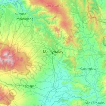
Name: Malaybalay topographic map, elevation, terrain.
Location: Malaybalay, Bukidnon, Northern Mindanao, Philippines (7.94438 124.92223 8.33614 125.41324)
Average elevation: 851 m
Minimum elevation: 286 m
Maximum elevation: 2,878 m
Other topographic maps
Click on a map to view its topography, its elevation and its terrain.
Lake Apo
Philippines > Bukidnon > Valencia
Lake Apo is a crater lake in Barangay Guinoyoran in the city of Valencia in Bukidnon province in the Philippines. It is located in a hilly area about 640 metres (2,100 ft) in elevation, about 11 kilometres (6.8 mi) WSW of the city poblacion (town center). Lake Apo was awarded the cleanest inland body of water…
Average elevation: 643 m
Mount Kitanglad
Philippines > Bukidnon > Impasugong
Due to its high elevation, several communications and broadcasting companies constructed relay stations at the summit.
Average elevation: 2,393 m
Mount Dulang-Dulang
Philippines > Bukidnon > Sumilao
Mount Dulang-dulang, dubbed by Filipino mountaineers as "D2" and also known as Mount Katanglad, is the highest elevation peak in the Kitanglad Mountain Range, located in the north central portion of the province of Bukidnon in the island of Mindanao. It is the second highest mountain of the Philippines at…
Average elevation: 2,448 m