
Thank you for supporting this site ❤️
Make a donation
Make a donation
Loboc River topographic map
Click on the map to display elevation.
Thank you for supporting this site ❤️
Make a donation
Make a donation
About this map
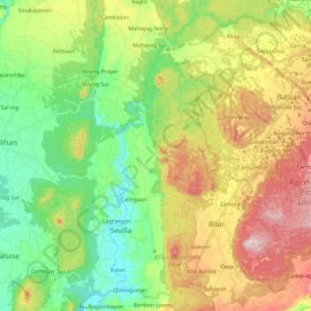
Name: Loboc River topographic map, elevation, terrain.
Location: Loboc River, Bohol, Central Visayas, Philippines (9.65532 124.02250 9.84129 124.21345)
Average elevation: 223 m
Minimum elevation: 27 m
Maximum elevation: 528 m
Thank you for supporting this site ❤️
Make a donation
Make a donation
Other topographic maps
Click on a map to view its topography, its elevation and its terrain.
Thank you for supporting this site ❤️
Make a donation
Make a donation
Thank you for supporting this site ❤️
Make a donation
Make a donation
Thank you for supporting this site ❤️
Make a donation
Make a donation
Thank you for supporting this site ❤️
Make a donation
Make a donation