
Make a donation
Parua Bay topographic map
Click on the map to display elevation.
Make a donation
About this map
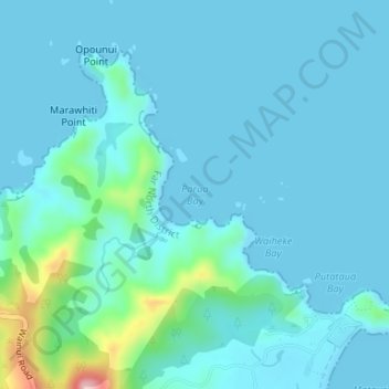
Name: Parua Bay topographic map, elevation, terrain.
Location: Parua Bay, Northland, New Zealand (-35.01931 173.90257 -35.01921 173.90267)
Average elevation: 22 m
Minimum elevation: 0 m
Maximum elevation: 186 m
Northland trails, hiking, mountain biking, running and outdoor activities
Make a donation
Other topographic maps
Click on a map to view its topography, its elevation and its terrain.
Kaeo River
New Zealand > Northland > Far North District > Bay of Islands-Whangaroa Community
Average elevation: 121 m
Make a donation
Waiparera Stream
New Zealand > Northland > Far North District > Te Hiku Community
Average elevation: 5 m
Utakura River
New Zealand > Northland > Far North District > Kaikohe-Hokianga Community
Average elevation: 124 m
Make a donation
Pungaere Stream
New Zealand > Northland > Far North District > Bay of Islands-Whangaroa Community
Average elevation: 183 m