
Reykjavik topographic map
Interactive map
Click on the map to display elevation.
About this map
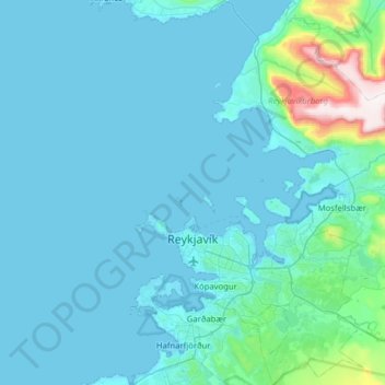
Name: Reykjavik topographic map, elevation, terrain.
Location: Reykjavik, Capital Region, Iceland (64.04040 -21.98383 64.31537 -21.40200)
Average elevation: 67 m
Minimum elevation: -3 m
Maximum elevation: 866 m
Other topographic maps
Click on a map to view its topography, its elevation and its terrain.
Seydisfjordur
Seydisfjordur, Múlaþing, Eastern Region, 710, Iceland
Average elevation: 443 m
Grindavík
Grindavík, Grindavíkurbær, Southern Peninsula, 240, Iceland
Average elevation: 27 m
Herðubreið
Herðubreið, Skútustaðahreppur, Northeastern Region, Iceland
Average elevation: 1,182 m
Tindfjallajökull
Tindfjallajökull, Hungurfitaskáli, Rangárþing ytra, Southern Region, Iceland
Average elevation: 1,059 m