
Make a donation
Koh Kong topographic map
Click on the map to display elevation.
Make a donation
About this map
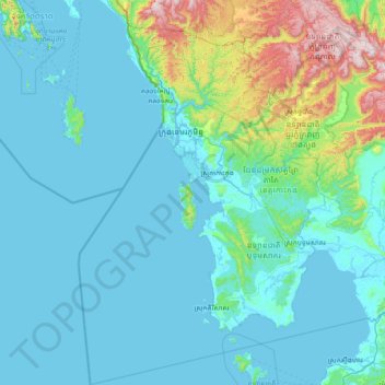
Name: Koh Kong topographic map, elevation, terrain.
Location: Koh Kong, Cambodia (10.65423 102.58498 12.11626 104.06456)
Average elevation: 142 m
Minimum elevation: -3 m
Maximum elevation: 1,299 m
Make a donation
Other topographic maps
Click on a map to view its topography, its elevation and its terrain.
Make a donation
Make a donation
Make a donation
Make a donation
Make a donation
Phum Prey Lvea
Cambodia > Phnom Penh > Khan Pou Senchey > Sangkat Chaom Chau 2
Average elevation: 13 m
Make a donation
Phum Trapeang Svay
Cambodia > Phnom Penh > Khan Sen Sok > Sangkat Kouk Khleang
Average elevation: 11 m
Make a donation
Make a donation
Phum Bourei Muoy Roy Khnorng
Cambodia > Phnom Penh > Khan Sen Sok > Sangkat Teuk Thla
Average elevation: 12 m
Make a donation
Make a donation
Make a donation
Make a donation
Make a donation
Make a donation
Make a donation
Make a donation
Phum Tuol Thngan
Cambodia > Phnom Penh > Khan Russey Keo > Sangkat Tuol Sangkae 2
Average elevation: 10 m
Make a donation
Phum Trapeang Chhuk
Cambodia > Phnom Penh > Khan Sen Sok > Sangkat Ou Baek K'am
Average elevation: 12 m
Make a donation
Make a donation
Sangkat Phsar Kandal Ti Pir
Cambodia > Phnom Penh > Khan Daun Penh > Sangkat Phsar Kandal Ti Pir
Average elevation: 12 m
Make a donation
Make a donation
Sangkat Phsar Kandal Ti Muoy
Cambodia > Phnom Penh > Khan Daun Penh > Sangkat Phsar Kandal Ti Muoy
Average elevation: 12 m
Phum Tuol Sambour
Cambodia > Phnom Penh > Khan Dangkao > Sangkat Prey Veng > Phum Tuol Sambour
Average elevation: 12 m
Make a donation
Make a donation