
Make a donation
Almaty topographic map
Click on the map to display elevation.
Make a donation
Almaty
Almaty is still the major commercial, financial, and cultural centre of Kazakhstan, as well as its most populous and most cosmopolitan city. The city is located in the mountainous area of southern Kazakhstan near the border with Kyrgyzstan in the foothills of the Trans-Ili Alatau at an elevation of 700–900 m (2,300–3,000 feet), where the Large and Small Almatinka rivers run into the plain. The city, just like Astana and Shymkent, does not belong to any region and is officially a "city of republican significance".
Make a donation
About this map
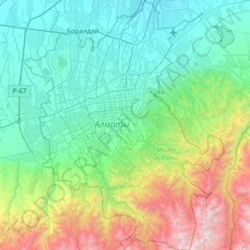
Name: Almaty topographic map, elevation, terrain.
Location: Almaty, Kazakhstan (43.03284 76.74205 43.40377 77.16675)
Average elevation: 1,474 m
Minimum elevation: 631 m
Maximum elevation: 4,386 m
Make a donation
Other topographic maps
Click on a map to view its topography, its elevation and its terrain.
Almaty
Almaty continues as the major commercial and cultural centre of Kazakhstan, as well as its most populous and most cosmopolitan city. The city is located in the mountainous area of southern Kazakhstan near the border with Kyrgyzstan in the foothills of the Trans-Ili Alatau at an elevation of 700–900 m…
Average elevation: 1,261 m
Ustyurt Plateau
Kazakhstan > Mangystau Region > Mangystau District
It extends roughly 200,000 km2 (77,000 sq mi), with an average altitude of 150 m (490 ft). Its highest point rises to 370 m (1,200 ft) in the south-west. At its northeastern edge it drops steeply to the Aral Sea and the surrounding plain.
Average elevation: 158 m
Make a donation
Talgar
Kazakhstan > Almaty Region > Talgar District
Talgar has a total area of 18.8 square km (7.3 mi²). The grade of the town's built-up areas is consistent with the natural unevenness of its overall natural geography. The average land elevation is 1250 m above sea level. The lowest points are in the northern part of the town at 1000 m, while the highest…
Average elevation: 1,037 m
Trans-Ili Alatau
Ile Alatau (Kazakh: Ile Alatauy, Іле Алатауы), also spelt as Trans-Ili Alatau, is a part of the Northern Tian Shan mountain system (ancient Mount Imeon) in Kazakhstan and Kyrgyzstan. It is the northernmost mountain range of Tian Shan, stretching for about 350 km (220 mi) with a maximal elevation of…
Average elevation: 2,059 m
Make a donation
Make a donation
Park named after the First President of the Republic of Kazakhstan
Average elevation: 1,020 m
Kok Tobe
Engineers chose the Köktöbe hill due to its high altitude (1130 meters above sea level, approximately 200 meters above the city). This elevation provided optimal coverage for the tower. The design was created in collaboration with the Moscow Institute of Central Research Institute of Cryogenics, and the…
Average elevation: 988 m
Make a donation
Make a donation
Make a donation
Петерфельд
Kazakhstan > North Kazakhstan Region > Qyzyljar District > Петерфельд ауылдық округі
Average elevation: 127 m
Make a donation
Бегимбет
Kazakhstan > Aqtöbe region > Şalqar District
Begimbet, also known as Sarybulak, (Kazakh: Бегімбет, Begımbet, بەگىمبەت; Russian: Бегимбет, Begimbet) is a town in Aktobe Region, west Kazakhstan. It lies at an altitude of 169 m (554 ft).
Average elevation: 171 m
Inderbor
Kazakhstan > Atyrau Region > Ïnder district > Индербор кенттік әкімдігі
Inderbor, also known as Inderborskiy, (Kazakh: Индербор, İnderbor, يندەربور; Russian: Индерборский, Inderborskiy) is a town in Atyrau Region, southwest Kazakhstan. It lies at an altitude of 27 m (89 ft) and has a population of 13,254.
Average elevation: 3 m
Жаңақала
Kazakhstan > West Kazakhstan Region > Zhanakala District > Жаңақала ауылдық округі
Average elevation: 3 m
Make a donation
Винное
Kazakhstan > East Kazakhstan Region > Glubokoe District > Тарханка ауылдық округі
Average elevation: 379 m
Betpak-Dala
Kazakhstan > Ulytau Region > Janaarqa District
The Betpak-Dala is located between the lower reaches of the Sarysu River, the Chu River, and Lake Balkhash. In the north, near the 46°30’ parallel, Betpak-Dala borders on the Kazakh Uplands, an area of low, rounded, isolated hills. Its area is approximately 75,000 square kilometres (29,000 sq mi). To the…
Average elevation: 331 m
Make a donation
Baikonur
The Soviet government established the Nauchno-Issledovatel'skii Ispytatel'nyi Poligon N.5 (NIIIP-5), or Scientific-Research Test Range N.5 by its decree of 12 February 1955. The U-2 high-altitude reconnaissance plane found and photographed the Tyuratam missile test range (cosmodrome Baikonur) for the first…
Average elevation: 100 m
Make a donation
Qaskeleñ
Kazakhstan > Almaty Region > Qarasay District > Қаскелең қаласының әкімшілігі
Average elevation: 874 m
Novopavlovka
Kazakhstan > North Kazakhstan Region > Petropavl Public Administration
Average elevation: 113 m
Ustyurt Plateau
Kazakhstan > Mangystau Region > Mangystau District
It extends roughly 200,000 km2 (77,000 sq mi), with an average altitude of 150 m (490 ft). Its highest point rises to 370 m (1,200 ft) in the south-west. At its northeastern edge it drops steeply to the Aral Sea and the surrounding plain.
Average elevation: 158 m
Make a donation
Narynkol
Kazakhstan > Almaty Region > Rayımbek district
Narynkol (Kazakh: Нарынқол, Narynqol) - A village in Raiymbek District of Almaty Region of Kazakhstan. It is the administrative center of Narynkol rural district. Located near the border with China, about 82 km east-south-east (ESE) from Kegen, the administrative center of Raiymbek District, at an…
Average elevation: 1,822 m
Make a donation
Make a donation
Aksay
Kazakhstan > West Kazakhstan Region > Börli district > Ақсай қалалық әкімдігі
Average elevation: 68 m
Байқоныс
Kazakhstan > West Kazakhstan Region > Baiterek District > Байқоныс ауылдық округі
Average elevation: 38 m
Ақтөбе
Kazakhstan > Turkistan Region > Zhetisay District > Қызылқұм ауылдық округі
Average elevation: 258 m
Make a donation
Peremetnoe
Kazakhstan > West Kazakhstan Region > Baiterek District > Перемётное ауылдық округі
Average elevation: 64 m
Makhambet
Kazakhstan > Atyrau Region > Makhambet District > Махамбет ауылдық округі
Makhambet (Kazakh: Махамбет, Mahambet, ماحامبەت; Russian: Махамбет, Makhambet) is a town in Atyrau Region, west Kazakhstan. It lies at an altitude of 8 m (26 ft) below sea level. It has a population of 8,905.
Average elevation: -17 m
Жалпактал
Kazakhstan > West Kazakhstan Region > Kaztal District > Жалпақтал ауылдық округі
Average elevation: 9 m
Make a donation
Kokshetau
It was the administrative center of Kokshetau Region (oblast) from 1944 to 1991 as part of the Soviet Union and from 1991 as part of Kazakhstan to 1997 when it was abolished. It is also situated at the junction of the Trans-Kazakhstan and South Siberian railways. Kokshetau lies at an elevation of approximately…
Average elevation: 248 m
Өнеге
Kazakhstan > West Kazakhstan Region > Zhanybek District > Күйгенкөл ауылдық округі
Average elevation: 40 m
Make a donation
Novopavlovka
Kazakhstan > North Kazakhstan Region > Petropavl Public Administration
Average elevation: 113 m
Make a donation
Жоғарғы Үбі
Kazakhstan > East Kazakhstan Region > Shemonaikha District > Жоғарғы Үбі ауылдық округі
Average elevation: 368 m
Qorğaljın
Kazakhstan > Akmola Region > Qorğaljın district
The village is located on the Kazakh Uplands. The average altitude in the village is about 330 meters above sea level. The terrain is a continuous plain with small hills and water areas.
Average elevation: 330 m
Караганды
Kazakhstan > West Kazakhstan Region > Syrym District > Шолақаңқаты ауылдық округі
Average elevation: 41 m
Make a donation
Border Kazakhstan - Russia
Kazakhstan > East Kazakhstan Region > Katonkaragay District
Average elevation: 2,676 m
Make a donation
Make a donation
Make a donation
Make a donation
Make a donation
Make a donation
Atakent
Kazakhstan > Turkistan Region > Maqtaaral District > Ильич кенттік әкімдігі
Average elevation: 263 m
Make a donation