
Torbalı topographic map
Interactive map
Click on the map to display elevation.
About this map
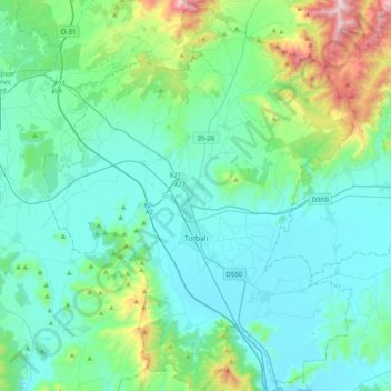
Name: Torbalı topographic map, elevation, terrain.
Location: Torbalı, Izmir, Aegean Region, Turkey (38.02912 27.20658 38.34028 27.52318)
Average elevation: 194 m
Minimum elevation: 2 m
Maximum elevation: 1,156 m
Other topographic maps
Click on a map to view its topography, its elevation and its terrain.
Gümüşhane
Gümüşhane (Turkish: [ɟyˈmyʃhaːne] ) is a city in the Black Sea Region of Turkey. It is the seat of Gümüşhane Province and Gümüşhane District. Its population is 39,214 (2022). The city lies along the Harşit River, about 40 miles (64 km) southwest of Trabzon. The city lies at an elevation of 1,153 m (3,783 ft).
Average elevation: 1,805 m
Kastamonu
Kastamonu, formerly Kastamone/Castamone (Greek: Κασταμονή) and Kastamon/Castamon (Greek: Κασταμών), is a city in northern Turkey. It is the seat of Kastamonu Province and Kastamonu District. Its population is 125,622 (2021). The city lies at an elevation of 904 m (2,966 ft). It is located in…
Average elevation: 1,169 m
Ankara
Ankara has a cold semi-arid climate under the Köppen climate classification (BSk), while under the Trewartha climate classification, the city is classified as humid continental (Dc). Due to its elevation and inland location, Ankara has cold and snowy winters, and hot and dry summers. Rainfall occurs mostly…
Average elevation: 1,082 m
Şanlıurfa
An important consideration in domestic architecture is mahremiyat, which could roughly be translated into English as "privacy" or "intimacy" but which carries stronger implications. This concept is especially important when it comes to relations between men and women – outside the extended family,…
Average elevation: 623 m
Harran
The precise location of the ancient great Ekhulkhul temple is unknown and no certain archaeological evidence of it has yet been found. It is likely that one of the major medieval buildings of Harran displaced the Elkhulkhul and were constructed on top of it, either the Harran Castle or the Grand Mosque.…
Average elevation: 428 m
Kayseri
Kayseri sits at the foot of Mount Erciyes (Turkish: Erciyes Dağı), a dormant volcano that reaches an altitude of 3,916 metres (12,848 feet), more than 1,500 metres above the city's mean altitude. It contains a number of historic monuments, particularly from the Seljuk period. Tourists often pass through…
Average elevation: 1,345 m
Artvin Province
Artvin is an attractive area of steep valleys carved by the Çoruh River system, surrounded by high mountains of Kaçkar, Karçal and Yalnızçam (up to 3900 m) and forest with much national parkland including the Karagöl-Sahara, which contains the Şavşat and Borçka lakes. The weather in Artvin is very wet…
Average elevation: 1,525 m
Salihli
The city of Salihli, the seat of the district, is located on İzmir-Ankara (E 96) highway and the parallel railway connections. The urban zone is situated on the slopes of Bozdağ mountain chain along the southern alluvial plains of the Gediz River. To the north and northeast of the plain extend two other…
Average elevation: 157 m
Devrekani
Turkey > Devrekani > Devrekani
Devrekani is a town and district of the Kastamonu Province in the Black Sea region of Turkey. According to the 2000 census, population of the district is 15,855 of which 6,174 live in the town of Devrekani. The district covers an area of 599 km2 (231 sq mi), and the town lies at an elevation of 1,116 m (3,661…
Average elevation: 1,108 m