Geolocate

Greene County topographic map

Interactive map

Click on the map to display elevation.

About this map

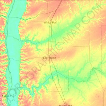
Name: Greene County topographic map, elevation, terrain.

Location: Greene County, Illinois, United States (39.11858 -90.62222 39.52153 -90.15016)

Average elevation: 168 m

Minimum elevation: 123 m

Maximum elevation: 245 m

Other topographic maps

Click on a map to view its topography, its elevation and its terrain.

Clark County

United States > Illinois

Average elevation: 178 m

Herod

United States > Illinois > Pope County

Average elevation: 168 m

St. Charles

United States > Illinois > Kane County

Average elevation: 234 m

Glencoe

United States > Illinois > Cook County

The village is surrounded on three sides by upper-income communities, with Highland Park on the north, Northbrook on the west, and Winnetka to the south. The Skokie Lagoons are located in the forest preserve to the immediate west of the village. The same forest preserve has a bicycle trail that connects to…

Average elevation: 194 m

Springfield

United States > Illinois > Sangamon County

The city is at an elevation of 558 feet (170 m) above sea level. According to the 2010 census, Springfield has a total area of 65.764 square miles (170.33 km2), of which 59.48 square miles (154.05 km2) (or 90.44%) is land and 6.284 square miles (16.28 km2) (or 9.56%) is water. The city is located in the Lower…

Average elevation: 178 m

Wheeling

United States > Illinois > Cook County

Average elevation: 202 m

Will County

United States > Illinois

Average elevation: 199 m

Leaf River

United States > Illinois > Ogle County

Average elevation: 227 m

Chillicothe

United States > Illinois > Peoria County

Average elevation: 146 m

Burnham Park

United States > Illinois > Cook County > Chicago

Average elevation: 179 m

Hillcrest

United States > Illinois > Ogle County

Average elevation: 251 m

Rock Island County

United States > Illinois

Average elevation: 213 m

Kenilworth

United States > Illinois > Cook County

Average elevation: 188 m

Johnsonville

United States > Illinois > Wayne County

Average elevation: 158 m

Glenwood

United States > Illinois > Cook County

Average elevation: 190 m

Logan County

United States > Illinois

Average elevation: 184 m

Melrose Park

United States > Illinois > Cook County

Average elevation: 194 m

North Aurora

United States > Illinois > Kane County

Average elevation: 218 m

Freeport

United States > Illinois > Stephenson County

Average elevation: 244 m

Aurora

United States > Illinois > Kane County

Average elevation: 212 m

Evanston

United States > Illinois > Cook County

Average elevation: 184 m

University Park

United States > Illinois > Will County

Average elevation: 229 m

Braidwood

United States > Illinois > Will County

Average elevation: 175 m

Taylorville

United States > Illinois > Christian County

Average elevation: 186 m

Burnham Park

United States > Illinois > Cook County > Chicago

Average elevation: 179 m

Mount Vernon

United States > Illinois > Jefferson County

Average elevation: 147 m

Chicago

United States > Illinois > Cook County

When Chicago was founded in 1837, most of the early building was around the mouth of the Chicago River, as can be seen on a map of the city's original 58 blocks. The overall grade of the city's central, built-up areas is relatively consistent with the natural flatness of its overall natural geography,…

Average elevation: 182 m

Hillcrest

United States > Illinois > Ogle County > Hillcrest

Average elevation: 246 m

Dunning

United States > Illinois > Chicago

Average elevation: 195 m

Oswego

United States > Illinois > Kendall County

Average elevation: 203 m

Winnetka

United States > Illinois > Winnetka

Average elevation: 189 m

Ottawa

United States > Illinois > Ottawa

Average elevation: 173 m

Adams County

United States > Illinois

Average elevation: 196 m

Champaign

United States > Illinois > Champaign

Average elevation: 226 m

Franklin Park

United States > Illinois > Franklin Park

Average elevation: 196 m

Pulaski County

United States > Illinois

Average elevation: 108 m

Jasper County

United States > Illinois

Average elevation: 162 m

Clinton County

United States > Illinois

Average elevation: 142 m

Union County

United States > Illinois

Average elevation: 149 m

Livingston County

United States > Illinois

Average elevation: 212 m

Cass County

United States > Illinois

Average elevation: 167 m