
Blue Mountain Peak topographic map
Interactive map
Click on the map to display elevation.
About this map
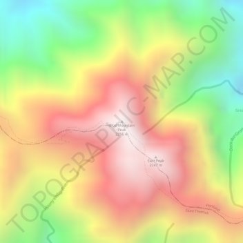
Name: Blue Mountain Peak topographic map, elevation, terrain.
Location: Blue Mountain Peak, Portland, Surrey County, Jamaica (18.04701 -76.57898 18.04711 -76.57888)
Average elevation: 1,808 m
Minimum elevation: 1,278 m
Maximum elevation: 2,234 m
Other topographic maps
Click on a map to view its topography, its elevation and its terrain.
Portmore
Jamaica > Saint Catherine > Portmore
Portmore, Saint Catherine, Middlesex County, YES, Jamaica
Average elevation: 148 m
Baptist
Baptist, Saint Elizabeth, Cornwall County, Jamaica
Average elevation: 73 m
Burnt Hill
Jamaica > Albert Town > Burnt Hill
Burnt Hill, Albert Town, Trelawny, Cornwall County, 123 659, Jamaica
Average elevation: 565 m
Mandeville
Mandeville, Manchester, Middlesex County, Jamaica
Average elevation: 615 m
Glasgow Road
Glasgow Road, Westmoreland, Cornwall County, Jamaica
Average elevation: 96 m
Albert Town
Albert Town, Trelawny, Cornwall County, Jamaica
Average elevation: 580 m