
Thank you for supporting this site ❤️
Make a donation
Make a donation
Lee County topographic map
Click on the map to display elevation.
Thank you for supporting this site ❤️
Make a donation
Make a donation
About this map
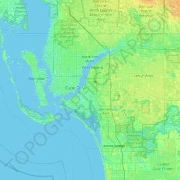
Name: Lee County topographic map, elevation, terrain.
Location: Lee County, Florida, United States (26.31613 -82.33504 26.78955 -81.56218)
Average elevation: 5 m
Minimum elevation: -2 m
Maximum elevation: 24 m
Thank you for supporting this site ❤️
Make a donation
Make a donation
Other topographic maps
Click on a map to view its topography, its elevation and its terrain.
Thank you for supporting this site ❤️
Make a donation
Make a donation
Thank you for supporting this site ❤️
Make a donation
Make a donation
Thank you for supporting this site ❤️
Make a donation
Make a donation
Lealman
United States > Florida > Pinellas County
Lealman is located at 27°49′10″N 82°41′4″W / 27.81944°N 82.68444°W / 27.81944; -82.68444 (27.8197, -82.6846). The community is bordered by the city of Pinellas Park to the north, St. Petersburg to the east and south, and by the town of West Lealman to the west. The elevation is 49 feet (15…
Average elevation: 13 m
Thank you for supporting this site ❤️
Make a donation
Make a donation
Thank you for supporting this site ❤️
Make a donation
Make a donation
Thank you for supporting this site ❤️
Make a donation
Make a donation
Thank you for supporting this site ❤️
Make a donation
Make a donation