
Fairfax County topographic map
Interactive map
Click on the map to display elevation.
Fairfax County
Most of the county lies in the Piedmont region, with rolling hills and deep stream valleys such as Difficult Run and its tributaries. West of Route 28, the hills give way to a flat, gentle valley which stretches west to the Bull Run Mountains in Loudoun County. Elevations in the county range from near sea level along the tidal sections of the Potomac River in the southeast portion of the county to more than 500 feet (150 m) in the Tysons Corner area.
About this map
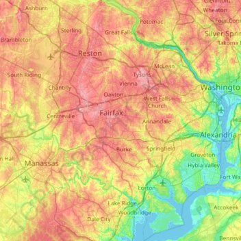
Name: Fairfax County topographic map, elevation, terrain.
Location: Fairfax County, Virginia, United States (38.60395 -77.53704 39.05763 -77.04057)
Average elevation: 75 m
Minimum elevation: -3 m
Maximum elevation: 168 m
Other topographic maps
Click on a map to view its topography, its elevation and its terrain.
Hawksbill
United States > Virginia > Madison County
Hawksbill Mountain is a mountain with an elevation of 4,050 feet (1,234 m). Marking the border between Madison County and Page County in Virginia, the summit of Hawksbill Mountain is the highest point in Shenandoah National Park, as well as the highest point in both Madison and Page counties.
Average elevation: 993 m