
Thank you for supporting this site ❤️
Make a donation
Make a donation
Iten topographic map
Click on the map to display elevation.
Thank you for supporting this site ❤️
Make a donation
Make a donation
About this map
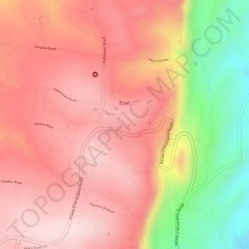
Name: Iten topographic map, elevation, terrain.
Location: Iten, Elgeyo-Marakwet County, Kenya (0.66406 35.49880 0.67736 35.51668)
Average elevation: 2,284 m
Minimum elevation: 2,057 m
Maximum elevation: 2,391 m
Thank you for supporting this site ❤️
Make a donation
Make a donation
Other topographic maps
Click on a map to view its topography, its elevation and its terrain.