
Ernakulam topographic map
Interactive map
Click on the map to display elevation.
About this map
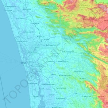
Name: Ernakulam topographic map, elevation, terrain.
Location: Ernakulam, Kerala, India (9.79242 76.16284 10.29418 77.08893)
Average elevation: 196 m
Minimum elevation: -5 m
Maximum elevation: 1,676 m
Other topographic maps
Click on a map to view its topography, its elevation and its terrain.
Powdiconam or Society Mukku
India > Kerala > Thiruvananthapuram
Powdiconam or Society Mukku, Thiruvananthapuram, Thiruvananthapuram District, Kerala, India
Average elevation: 46 m
Kakkadampoyil
India > Kerala > Thamarassery
Kakkadampoyil, Thamarassery, Kozhikode District, Kerala, 673604, India
Average elevation: 616 m
Kanhangad
India > Kerala > Hosdurg > Muriyanavi
Kanhangad, Muriyanavi, Hosdurg, Kasaragod district, Kerala, 671315, India
Average elevation: 19 m
Padapparamba
India > Kerala > Perinthalmanna
Padapparamba, Perinthalmanna, Malappuram, Kerala, 676507, India
Average elevation: 67 m
Aruvikkara
India > Kerala > Nedumangad
Aruvikkara, Nedumangad, Thiruvananthapuram, Kerala, 685541, India
Average elevation: 66 m
Karinkalkuzhi
India > Kerala > Taliparamba
Karinkalkuzhi, Taliparamba, Kannur district, Kerala, 670601, India
Average elevation: 20 m
Puthanathani
India > Kerala > Puthanathani
Puthanathani, Tirur, Malappuram, Kerala, India
Average elevation: 81 m
Meesapulimala
Meesapulimala, Idukki, Kerala, 685618, India
Average elevation: 2,221 m