
Thank you for supporting this site ❤️
Make a donation
Make a donation
Adama topographic map
Click on the map to display elevation.
Thank you for supporting this site ❤️
Make a donation
Make a donation
About this map
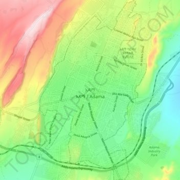
Name: Adama topographic map, elevation, terrain.
Location: Adama, Oromia Region, 0408, Ethiopia (8.49725 39.24379 8.58993 39.29963)
Average elevation: 1,675 m
Minimum elevation: 1,489 m
Maximum elevation: 1,978 m
Thank you for supporting this site ❤️
Make a donation
Make a donation
Other topographic maps
Click on a map to view its topography, its elevation and its terrain.