Roanoke County topographic map
Interactive map
Click on the map to display elevation.
Roanoke County topographic map, elevation, terrain
About this map
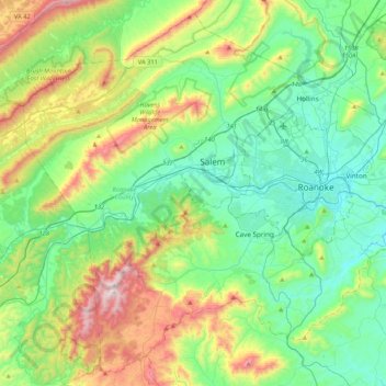
Name: Roanoke County topographic map, elevation, terrain.
Location: Roanoke County, Virginia, United States (37.10908 -80.26218 37.42247 -79.83955)
Average elevation: 517 m
Minimum elevation: 257 m
Maximum elevation: 1,187 m
Other topographic maps
Click on a map to view its topography, its elevation and its terrain.
Blacksburg
United States > Virginia > Montgomery County
In the mid-1600s, English colonists were still uncertain of what lay beyond the Allegheny Mountains, whose topography and possession by native inhabitants, Tutelo-speaking tribes, were a barrier to expanded settlement by the Colony of Virginia. Abraham Wood, who commanded Fort Henry on the frontier (now the…
Average elevation: 621 m
Hawksbill
United States > Virginia > Madison County
Hawksbill Mountain is a mountain with an elevation of 4,050 feet (1,234 m). Marking the border between Madison County and Page County in Virginia, the summit of Hawksbill Mountain is the highest point in Shenandoah National Park, as well as the highest point in both Madison and Page counties.
Average elevation: 993 m
Virginia Beach
According to the United States Census Bureau, the city has a total area of 497 square miles (1,290 km2), of which 249 square miles (640 km2) is land and 248 square miles (640 km2) (49.9%) is water. It is the largest city in Virginia by total area and third-largest city by land area. The average elevation is 12…
Average elevation: 2 m
Smithsonian Conservation Biology Institute
United States > Virginia > Warren County > Front Royal
Average elevation: 357 m
Carroll County
United States > Virginia > Carroll County
It is the only county in Virginia with Piedmont topography of roughly one fifth in the southeast part of the county and mountain topography of roughly four fifths elsewhere of the county. The Blue Ridge escarpment usually defines the county lines in both North Carolina and Virginia. The CDP community of Cana…
Average elevation: 709 m
Lynchburg
United States > Virginia > Lynchburg
Lynchburg has a four-season humid subtropical climate (Köppen Cfa), with cool winters and hot, humid summers. The monthly daily average temperature ranges from 35.9 °F (2.2 °C) in January to 76.0 °F (24.4 °C) in July. Nights tend to be significantly cooler than days throughout much of the year due in part…
Average elevation: 229 m
Fairfax County
Most of the county lies in the Piedmont region, with rolling hills and deep stream valleys such as Difficult Run and its tributaries. West of Route 28, the hills give way to a flat, gentle valley which stretches west to the Bull Run Mountains in Loudoun County. Elevations in the county range from near sea…
Average elevation: 75 m