
Ruapuke Beach topographic map
Click on the map to display elevation.
About this map
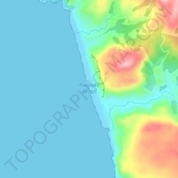
Name: Ruapuke Beach topographic map, elevation, terrain.
Location: Ruapuke Beach, Waikato District, Waikato, New Zealand (-37.91621 174.76194 -37.88909 174.77544)
Average elevation: 35 m
Minimum elevation: 0 m
Maximum elevation: 160 m
Waikato District trails, hiking, mountain biking, running and outdoor activities
Other topographic maps
Click on a map to view its topography, its elevation and its terrain.