
Idaho topographic map
Interactive map
Click on the map to display elevation.
About this map
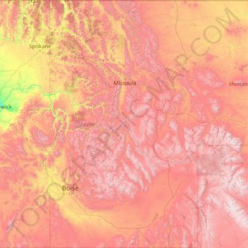
Name: Idaho topographic map, elevation, terrain.
Location: Idaho, United States (41.98883 -117.24303 49.00084 -111.04356)
Average elevation: 1,533 m
Minimum elevation: 102 m
Maximum elevation: 4,034 m
Idaho's climate varies widely. Although the state's western border is about 330 miles (530 km) from the Pacific Ocean, the maritime influence is still felt in Idaho; especially, in the winter when cloud cover, humidity, and precipitation are at their maximum extent. This influence has a moderating effect in the winter where temperatures are not as low as would otherwise be expected for a northern state with predominantly high elevations. In the panhandle, moist air masses from the coast are released as precipitation over the North Central Rockies forests, creating the North American inland temperate rainforest. The maritime influence is least prominent in the state's eastern part where the precipitation patterns are often reversed, with wetter summers and drier winters, and seasonal temperature differences are more extreme, showing a more semi-arid continental climate.
Other topographic maps
Click on a map to view its topography, its elevation and its terrain.
Houston
United States > Texas > Harris County
Houston, Harris County, Texas, United States
Average elevation: 25 m
Montgomery County
Montgomery County, Texas, United States
Average elevation: 69 m
Charlotte County
Charlotte County, Florida, United States
Average elevation: 10 m
Staten Island
United States > New York > New York
Staten Island, Richmond County, New York, United States
Average elevation: 9 m
Indianapolis
United States > Indiana > Indianapolis
Indianapolis, Marion County, Indiana, 46204, United States
Average elevation: 241 m
New Orleans
United States > Louisiana > Orleans Parish
New Orleans, Orleans Parish, Louisiana, United States
Average elevation: 1 m
Jacksonville
United States > Florida > Duval County
Jacksonville, Duval County, Florida, United States
Average elevation: 10 m
Ellicott City
United States > Maryland > Howard County
Ellicott City, Howard County, Maryland, 21043, United States
Average elevation: 119 m
Santa Fe
United States > New Mexico > Santa Fe County
Santa Fe, Santa Fe County, New Mexico, United States
Average elevation: 2,221 m
Boston
United States > Massachusetts > Suffolk County
Boston, Suffolk County, Massachusetts, United States
Average elevation: 25 m
West Dennis
United States > Massachusetts > Barnstable County > Dennis
West Dennis, Dennis, Barnstable County, Massachusetts, 02670, United States
Average elevation: 1 m
Watauga County
United States > North Carolina
Watauga County, North Carolina, United States
Average elevation: 984 m
Frederick County
Frederick County, Maryland, United States
Average elevation: 186 m
Knoxville
United States > Tennessee > Knox County
Knoxville, Knox County, East Tennessee, Tennessee, United States
Average elevation: 307 m
Norfolk
United States > Virginia > Norfolk
Norfolk, Virginia, 23510, United States
Average elevation: 4 m
Newton
United States > Massachusetts > Middlesex County
Newton, Middlesex County, Massachusetts, United States
Average elevation: 38 m
Madison
United States > Wisconsin > Dane County
Madison, Dane County, Wisconsin, United States
Average elevation: 284 m
Nashville-Davidson
United States > Tennessee > Davidson County
Nashville-Davidson, Davidson County, Middle Tennessee, Tennessee, United States
Average elevation: 184 m
Jacksonville
United States > Florida > Duval County > Jacksonville
Jacksonville, Duval County, Florida, 32202, United States
Average elevation: 9 m
Middle East
United States > Maryland > Baltimore
Middle East, Baltimore, Maryland, United States
Average elevation: 29 m
Fort Worth
United States > Texas > Tarrant County
Fort Worth, Tarrant County, Texas, United States
Average elevation: 212 m
Camden County
Camden County, New Jersey, United States
Average elevation: 26 m