
Central Okanagan topographic map
Interactive map
Click on the map to display elevation.
About this map
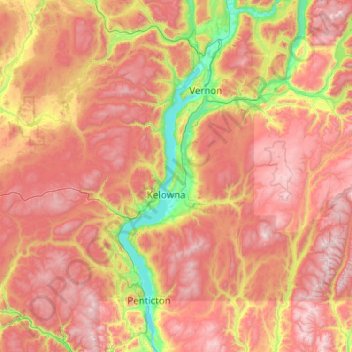
Name: Central Okanagan topographic map, elevation, terrain.
Location: Central Okanagan, British Columbia, V1V 1Y8, Canada (49.31272 -120.08244 50.59272 -118.80244)
Average elevation: 1,223 m
Minimum elevation: 334 m
Maximum elevation: 2,376 m
Other topographic maps
Click on a map to view its topography, its elevation and its terrain.
Victoria
Canada > British Columbia > Capital Regional District
Victoria, British Columbia, is situated on the southern tip of Vancouver Island, Canada, and boasts a diverse and varied topography. The city is characterized by rolling hills, rugged coastal cliffs, and lush valleys, providing a striking contrast between mountainous terrain and flatland areas. To the north…
Average elevation: 17 m
Muskwa River
Canada > British Columbia > Peace River Regional District > Area B (Finlay Valley/Beatton Valley)
Average elevation: 1,496 m
Suscha Lake
Canada > British Columbia > Cariboo Regional District > Area I (West Fraser/Nazko)
Average elevation: 1,140 m
Coyle Park
Canada > British Columbia > Regional District of Fraser-Fort George > Prince George
Average elevation: 625 m
Rubble Creek
Canada > British Columbia > Squamish-Lillooet Regional District > Area D (Elaho/Garibaldi)
Average elevation: 787 m
François Lake
Canada > British Columbia > Regional District of Bulkley-Nechako > Area E (Ootsa Lake/François Lake)
Equity Silver is a weather station roughly 20 km (12.4 miles) north of François Lake, at an elevation of 1280 m (4199 ft). Equity Silver has a subarctic climate (Köppen Dfc), bordering on a tundra climate (Köppen ET).
Average elevation: 984 m
Fort St. James
Canada > British Columbia > Regional District of Bulkley-Nechako
Average elevation: 831 m
Lyell Creek
Canada > British Columbia > Columbia-Shuswap Regional District > Area A (Kicking Horse/Kinbasket Lake)
Average elevation: 1,323 m
Isobel Lake
Canada > British Columbia > Thompson-Nicola Regional District > Area J (Copper Desert Country)
Average elevation: 1,058 m
Mink Lake
Canada > British Columbia > Regional District of Bulkley-Nechako > Area E (Ootsa Lake/François Lake)
Average elevation: 898 m
Area D (Oyster Bay/Buttle Lake)
Canada > British Columbia > Strathcona Regional District
Average elevation: 723 m
Napier Island
Canada > British Columbia > Central Coast Regional District > Area A (Ocean Falls/Outer Coast)
Average elevation: 4 m
Trail
Canada > British Columbia > Regional District of Kootenay Boundary > Trail
Summer climate in Trail is generally hot and dry with moderately cool nights. Temperatures often exceed 35 °C (95 °F) during summer afternoons, average 29 °C (84 °F). Thunderstorms are common during the late-Spring and Summer season, often moving into the valley from the south. The fall months bring dense…
Average elevation: 934 m
Whistler Resort Municipality
Canada > British Columbia > Squamish-Lillooet Regional District
Average elevation: 1,343 m
Kelowna
Canada > British Columbia > Regional District of Central Okanagan
Kelowna is classified as a humid continental climate or an inland oceanic climate per the Köppen climate classification system due to its coldest month having an average temperature slightly above −3.0 °C (26.6 °F) and below 0 °C (32 °F), with dry, hot, sunny summers and cool, cloudy winters, and four…
Average elevation: 704 m
Fairview
Canada > British Columbia > Metro Vancouver Regional District > Vancouver
Average elevation: 31 m
Bowen Island
Canada > British Columbia > Metro Vancouver Regional District > Bowen Island Municipality
Average elevation: 106 m
Vancouver Island
The rain shadow effect of the island's mountains, as well as the mountains of Washington's Olympic Peninsula, creates wide variation in precipitation. The west coast is considerably wetter than the east coast. Average annual precipitation ranges from 6,650 mm (262 in) at Hucuktlis Lake on the west coast…
Average elevation: 411 m
Pender Harbour
Canada > British Columbia > Sunshine Coast Regional District > Area A (Egmont/Pender Harbour) > Madeira Park
Average elevation: 110 m
North Vancouver
Canada > British Columbia > Metro Vancouver Regional District > North Vancouver
Average elevation: 54 m
Saltspring Island
Canada > British Columbia > Capital Regional District > Salt Spring Island Electoral Area
Average elevation: 72 m
Tsable River
Canada > British Columbia > Comox Valley Regional District > Area A (Baynes Sound)
Average elevation: 493 m
Prince George
Canada > British Columbia > Regional District of Fraser-Fort George
Average elevation: 685 m
Burnaby
Canada > British Columbia > Metro Vancouver Regional District > Burnaby
Burnaby occupies 98.60 square kilometres (38.07 sq mi) and is located at the geographic centre of the Metro Vancouver area and home to the Metro Vancouver regional government in Metrotown. Situated between the city of Vancouver on the west and Port Moody, Coquitlam, and New Westminster on the east, Burnaby is…
Average elevation: 59 m
District of North Vancouver
Canada > British Columbia > District of North Vancouver
Average elevation: 358 m
Fintry Provincial Park
Canada > British Columbia > West Central Okanagan Electoral Area
Average elevation: 420 m
Golden
Canada > British Columbia > Columbia-Shuswap Regional District > Golden
Average elevation: 880 m