
Vancouver Island topographic map
Interactive map
Click on the map to display elevation.
About this map
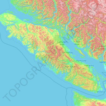
Name: Vancouver Island topographic map, elevation, terrain.
Location: Vancouver Island, British Columbia, Canada (48.30888 -128.43292 50.87683 -123.26476)
Average elevation: 411 m
Minimum elevation: -3 m
Maximum elevation: 3,160 m
Other topographic maps
Click on a map to view its topography, its elevation and its terrain.
Suscha Lake
Canada > British Columbia > Cariboo Regional District > Area I (West Fraser/Nazko)
Average elevation: 1,140 m
Coyle Park
Canada > British Columbia > Regional District of Fraser-Fort George > Prince George
Average elevation: 625 m
Mount Albert
Canada > British Columbia > Sunshine Coast Regional District > Area A (Egmont/Pender Harbour)
Average elevation: 1,937 m
Rubble Creek
Canada > British Columbia > Squamish-Lillooet Regional District > Area D (Elaho/Garibaldi)
Average elevation: 787 m
Stoney Creek
Canada > British Columbia > Regional District of Central Kootenay > Area K (The Arrow Lakes)
Average elevation: 1,295 m
Appledale
Canada > British Columbia > Regional District of Central Kootenay > Area H (The Slocan Valley)
Average elevation: 707 m
Fort St. James
Canada > British Columbia > Regional District of Bulkley-Nechako
Average elevation: 831 m
François Lake
Canada > British Columbia > Regional District of Bulkley-Nechako > Area E (Ootsa Lake/François Lake)
Equity Silver is a weather station roughly 20 km (12.4 miles) north of François Lake, at an elevation of 1280 m (4199 ft). Equity Silver has a subarctic climate (Köppen Dfc), bordering on a tundra climate (Köppen ET).
Average elevation: 984 m
Mount Hobson
Canada > British Columbia > Regional District of Bulkley-Nechako > Area D (Endako/Fort Fraser)
Average elevation: 1,079 m
Isobel Lake
Canada > British Columbia > Thompson-Nicola Regional District > Area J (Copper Desert Country)
Average elevation: 1,058 m
Lyell Creek
Canada > British Columbia > Columbia-Shuswap Regional District > Area A (Kicking Horse/Kinbasket Lake)
Average elevation: 1,323 m
Mink Lake
Canada > British Columbia > Regional District of Bulkley-Nechako > Area E (Ootsa Lake/François Lake)
Average elevation: 898 m
Area D (Oyster Bay/Buttle Lake)
Canada > British Columbia > Strathcona Regional District
Average elevation: 723 m
Napier Island
Canada > British Columbia > Central Coast Regional District > Area A (Ocean Falls/Outer Coast)
Average elevation: 4 m
Whistler Resort Municipality
Canada > British Columbia > Squamish-Lillooet Regional District
Average elevation: 1,343 m
Fairview
Canada > British Columbia > Metro Vancouver Regional District > Vancouver
Average elevation: 31 m
Area G (Forster Creek/Mount Assiniboine)
Canada > British Columbia > Regional District of East Kootenay
Average elevation: 2,710 m
Trail
Canada > British Columbia > Regional District of Kootenay Boundary > Trail
Summer climate in Trail is generally hot and dry with moderately cool nights. Temperatures often exceed 35 °C (95 °F) during summer afternoons, average 29 °C (84 °F). Thunderstorms are common during the late-Spring and Summer season, often moving into the valley from the south. The fall months bring dense…
Average elevation: 934 m
Kelowna
Canada > British Columbia > Regional District of Central Okanagan
Kelowna is classified as a humid continental climate or an inland oceanic climate per the Köppen climate classification system due to its coldest month having an average temperature slightly above −3.0 °C (26.6 °F) and below 0 °C (32 °F), with dry, hot, sunny summers and cool, cloudy winters, and four…
Average elevation: 704 m
Bowen Island
Canada > British Columbia > Metro Vancouver Regional District > Bowen Island Municipality
Average elevation: 106 m
Glacier Bay
Canada > British Columbia > Area F (McConnell Creek/Hatzic Prairie)
Average elevation: 189 m
Nelson
Canada > British Columbia > Regional District of Central Kootenay > Nelson
Average elevation: 1,422 m
Middle Hill
Canada > British Columbia > North Coast Regional District > Area D (Graham Island)
Average elevation: 248 m
Rivervale
Canada > British Columbia > Regional District of Kootenay Boundary > Area B (Lower Columbia/Old Glory)
Average elevation: 610 m
Garden Bay
Canada > British Columbia > Sunshine Coast Regional District > Area A (Egmont/Pender Harbour) > Garden Bay
Average elevation: 79 m
McMurdo
Canada > British Columbia > Columbia-Shuswap Regional District > Area A (Kicking Horse/Kinbasket Lake)
Average elevation: 852 m
North Vancouver
Canada > British Columbia > Metro Vancouver Regional District > North Vancouver
Average elevation: 54 m
Pender Harbour
Canada > British Columbia > Sunshine Coast Regional District > Area A (Egmont/Pender Harbour) > Madeira Park
Average elevation: 110 m
Saltspring Island
Canada > British Columbia > Capital Regional District > Salt Spring Island Electoral Area
Average elevation: 72 m
Tsable River
Canada > British Columbia > Comox Valley Regional District > Area A (Baynes Sound)
Average elevation: 493 m
Fanny Bay
Canada > British Columbia > Comox Valley Regional District > Area A (Baynes Sound) > Fanny Bay
Average elevation: 36 m
Courtenay
Canada > British Columbia > Comox Valley Regional District > Courtenay
Average elevation: 187 m