
Arsi topographic map
Interactive map
Click on the map to display elevation.
About this map
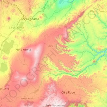
Name: Arsi topographic map, elevation, terrain.
Location: Arsi, Oromia Region, Ethiopia (7.15437 38.68779 8.86323 40.71720)
Average elevation: 2,011 m
Minimum elevation: 861 m
Maximum elevation: 4,186 m
Other topographic maps
Click on a map to view its topography, its elevation and its terrain.
Metahara
Metahara, East Shewa, Oromia Region, Ethiopia
Average elevation: 970 m
Guto
Guto, South West Shewa, Oromia Region, Ethiopia
Average elevation: 2,867 m
Ahmar Mountains
Ahmar Mountains, West Harerghe, Oromia Region, Ethiopia
Average elevation: 1,777 m