
Montgomery County topographic map
Interactive map
Click on the map to display elevation.
About this map
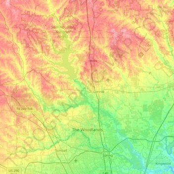
Name: Montgomery County topographic map, elevation, terrain.
Location: Montgomery County, Texas, United States (30.02618 -95.83016 30.63042 -95.09665)
Average elevation: 69 m
Minimum elevation: 13 m
Maximum elevation: 147 m
Other topographic maps
Click on a map to view its topography, its elevation and its terrain.
Seymour
United States > Texas > Baylor County
The climate is humid subtropical (Köppen: Cfa) with an extreme temperature deviation, but much of the time, the variation is always more and the warm weather prevails over the cold as the averages and the records show. Its subtropical location and south of the center of a large land mass bring occasional…
Average elevation: 401 m
Houston
United States > Texas > Harris County > Houston
Houston is located 165 miles (266 km) east of Austin, 88 miles (142 km) west of the Louisiana border, and 250 miles (400 km) south of Dallas. The city has a total area of 637.4 square miles (1,651 km2); this comprises over 599.59 square miles (1,552.9 km2) of land and 22.3 square miles (58 km2) covered by…
Average elevation: 18 m
Austin
United States > Texas > Travis County > Austin
The elevation of Austin varies from 425 feet (130 m) to approximately 1,000 feet (305 m) above sea level. Due to the fact it straddles the Balcones Fault, much of the eastern part of the city is flat, with heavy clay and loam soils, whereas the western part and western suburbs consist of rolling hills on the…
Average elevation: 203 m
Dallas
United States > Texas > Dallas County > Dallas
Dallas and its surrounding area are mostly flat. The city lies at elevations ranging from 450 to 550 feet (137 to 168 m) above sea level. The western edge of the Austin Chalk Formation, a limestone escarpment (also known as the "White Rock Escarpment"), rises 230 feet (70 m) and runs roughly north–south…
Average elevation: 158 m