
Lake Te Anau topographic map
Interactive map
Click on the map to display elevation.
Lake Te Anau
Lake Te Anau (Māori: Te Ana-au) is in the southwestern corner of the South Island of New Zealand. The lake covers an area of 344 km2 (133 sq mi), making it the second-largest lake by surface area in New Zealand (after Lake Taupō) and the largest in the South Island. It is the second largest lake in Australasia by fresh water volume. The main body of the lake runs north-south, and is 65 km in length. Three large fiords form arms to the lake on its western flank: North Fiord, Middle Fiord and South Fiord. These are the only inland fiords that New Zealand has, the other 14 are out on the coast. Several small islands lie in the entrance to Middle Fiord, which forks partway along its length into northwest and southwest arms. The surface of the lake is at an altitude of 210 m. It has a maximum depth of 425 m, so much of its bed lies below sea level, with the deepest part of the lake being 215 metres below sea level.
About this map
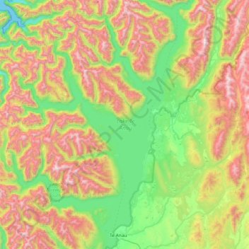
Name: Lake Te Anau topographic map, elevation, terrain.
Location: Lake Te Anau, Southland District, Southland, New Zealand (-45.44237 167.42663 -44.92906 167.93376)
Average elevation: 684 m
Minimum elevation: 0 m
Maximum elevation: 1,831 m
Southland District trails, hiking, mountain biking, running and outdoor activities
Other topographic maps
Click on a map to view its topography, its elevation and its terrain.
Fortrose
New Zealand > Southland > Southland District > Waihopai Toetoe Community
Average elevation: 12 m
Hikuraki / North Mavora Lake
New Zealand > Southland > Southland District > Fiordland Community
Average elevation: 1,071 m
Tokanui
New Zealand > Southland > Southland District > Waihopai Toetoe Community
Average elevation: 85 m
Wairaki
New Zealand > Southland > Southland District > Tuatapere Te Waewae Community
Average elevation: 100 m
Orepuki
New Zealand > Southland > Southland District > Tuatapere Te Waewae Community
Average elevation: 22 m
Redan
New Zealand > Southland > Southland District > Waihopai Toetoe Community
Average elevation: 109 m
Table Mount
New Zealand > Southland > Southland District > Fiordland Community
Average elevation: 816 m
Wyndham
New Zealand > Southland > Southland District > Waihopai Toetoe Community
Average elevation: 32 m
Pahia
New Zealand > Southland > Southland District > Tuatapere Te Waewae Community
Average elevation: 15 m
Rakahouka
New Zealand > Southland > Southland District > Waihopai Toetoe Community
Average elevation: 38 m
Longbush
New Zealand > Southland > Southland District > Waihopai Toetoe Community
Average elevation: 32 m
Long Beach
New Zealand > Southland > Southland District > Waihopai Toetoe Community
Average elevation: 36 m
Mamaku Point
New Zealand > Southland > Southland District > Stewart Island / Rakiura Community
Average elevation: 14 m
Oban
New Zealand > Southland > Southland District > Stewart Island / Rakiura Community
Average elevation: 23 m
Dipton West
New Zealand > Southland > Southland District > Oreti Community > Dipton West
Average elevation: 132 m
Opio
New Zealand > Southland > Southland District > Wallace Takitimu Community > Opio
Average elevation: 175 m
Ohai
New Zealand > Southland > Southland District > Wallace Takitimu Community
Average elevation: 188 m
Slope Point
New Zealand > Southland > Southland District > Waihopai Toetoe Community > Slope Point
Average elevation: 36 m
Little River
New Zealand > Southland > Southland District > Stewart Island/Rakiura Community
Average elevation: 62 m
Thomsons Crossing
New Zealand > Southland > Southland District > Oreti Community > Thomsons Crossing
Average elevation: 42 m