
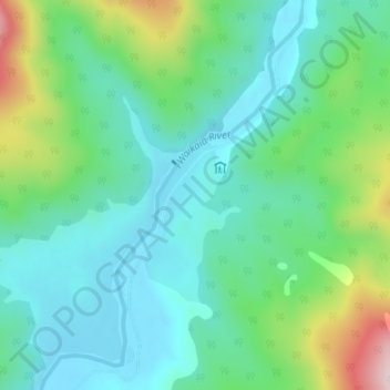
Piano Flat topographic map
Interactive map
Click on the map to display elevation.
About this map
Name: Piano Flat topographic map, elevation, terrain.
Average elevation: 295 m
Minimum elevation: 201 m
Maximum elevation: 558 m
Routes: Southland District GPS tracks, routes, trails, hikes
Other topographic maps
Click on a map to view its topography, its elevation and its terrain.
Tokanui
New Zealand > Southland > Southland District > Waihopai Toetoe Community
Average elevation: 85 m
Orepuki
New Zealand > Southland > Southland District > Tuatapere Te Waewae Community
Average elevation: 22 m
Wairaki
New Zealand > Southland > Southland District > Tuatapere Te Waewae Community
Average elevation: 100 m
Redan
New Zealand > Southland > Southland District > Waihopai Toetoe Community
Average elevation: 109 m
Milford Sound
New Zealand > Southland > Southland District > Fiordland Community
Average elevation: 655 m
Table Mount
New Zealand > Southland > Southland District > Fiordland Community
Average elevation: 816 m
Riverton
New Zealand > Southland > Southland District > Oraka Aparima Community
Average elevation: 16 m
Wyndham
New Zealand > Southland > Southland District > Waihopai Toetoe Community
Average elevation: 32 m
Pahia
New Zealand > Southland > Southland District > Tuatapere Te Waewae Community
Average elevation: 15 m
Rakahouka
New Zealand > Southland > Southland District > Waihopai Toetoe Community
Average elevation: 38 m
Longbush
New Zealand > Southland > Southland District > Waihopai Toetoe Community
Average elevation: 32 m
Long Beach
New Zealand > Southland > Southland District > Waihopai Toetoe Community
Average elevation: 36 m
Mamaku Point
New Zealand > Southland > Southland District > Stewart Island / Rakiura Community
Average elevation: 14 m
Dipton West
New Zealand > Southland > Southland District > Oreti Community > Dipton West
Average elevation: 132 m
Oban
New Zealand > Southland > Southland District > Stewart Island / Rakiura Community
Average elevation: 23 m
Opio
New Zealand > Southland > Southland District > Wallace Takitimu Community > Opio
Average elevation: 175 m
Ohai
New Zealand > Southland > Southland District > Wallace Takitimu Community
Average elevation: 188 m
Thomsons Crossing
New Zealand > Southland > Southland District > Oreti Community > Thomsons Crossing
Average elevation: 42 m
Slope Point
New Zealand > Southland > Southland District > Waihopai Toetoe Community > Slope Point
Average elevation: 36 m
Little River
New Zealand > Southland > Southland District > Stewart Island/Rakiura Community
Average elevation: 62 m
Milford Sound
New Zealand > Southland > Southland District > Fiordland Community
Average elevation: 304 m