
Make a donation
Northern Community topographic map
Click on the map to display elevation.
Make a donation
About this map
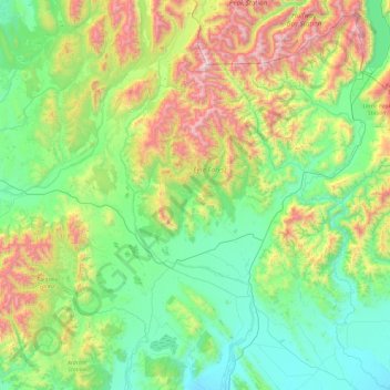
Name: Northern Community topographic map, elevation, terrain.
Average elevation: 600 m
Minimum elevation: 131 m
Maximum elevation: 1,972 m
Southland District trails, hiking, mountain biking, running and outdoor activities
Make a donation
Other topographic maps
Click on a map to view its topography, its elevation and its terrain.
Longbush
New Zealand > Southland > Southland District > Waihopai Toetoe Community
Average elevation: 32 m
Pahia
New Zealand > Southland > Southland District > Tuatapere Te Waewae Community
Average elevation: 15 m
Wyndham
New Zealand > Southland > Southland District > Waihopai Toetoe Community
Average elevation: 32 m
Make a donation
Hikuraki / North Mavora Lake
New Zealand > Southland > Southland District > Fiordland Community
Average elevation: 1,071 m
Fortrose
New Zealand > Southland > Southland District > Waihopai Toetoe Community
Average elevation: 12 m
Ohai
New Zealand > Southland > Southland District > Wallace Takitimu Community
Average elevation: 188 m
Make a donation
Oban
New Zealand > Southland > Southland District > Stewart Island / Rakiura Community
Average elevation: 23 m
Mamaku Point
New Zealand > Southland > Southland District > Stewart Island / Rakiura Community
Average elevation: 14 m
Long Beach
New Zealand > Southland > Southland District > Waihopai Toetoe Community
Average elevation: 36 m
Make a donation
Rakahouka
New Zealand > Southland > Southland District > Waihopai Toetoe Community
Average elevation: 38 m
Table Mount
New Zealand > Southland > Southland District > Fiordland Community
Average elevation: 816 m
Make a donation
Redan
New Zealand > Southland > Southland District > Waihopai Toetoe Community
Average elevation: 109 m
Wairaki
New Zealand > Southland > Southland District > Tuatapere Te Waewae Community
Average elevation: 100 m
Orepuki
New Zealand > Southland > Southland District > Tuatapere Te Waewae Community
Average elevation: 22 m
Tokanui
New Zealand > Southland > Southland District > Waihopai Toetoe Community
Average elevation: 85 m
Make a donation
Slope Point
New Zealand > Southland > Southland District > Waihopai Toetoe Community > Slope Point
Average elevation: 36 m
Little River
New Zealand > Southland > Southland District > Stewart Island/Rakiura Community
Average elevation: 62 m
Thomsons Crossing
New Zealand > Southland > Southland District > Oreti Community > Thomsons Crossing
Average elevation: 42 m
Make a donation
Opio
New Zealand > Southland > Southland District > Wallace Takitimu Community > Opio
Average elevation: 175 m
Dipton West
New Zealand > Southland > Southland District > Oreti Community > Dipton West
Average elevation: 132 m