
Whangaparaoa topographic map
Interactive map
Click on the map to display elevation.
About this map
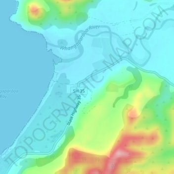
Name: Whangaparaoa topographic map, elevation, terrain.
Location: Whangaparaoa, Opotiki District, Bay of Plenty, New Zealand (-37.58441 177.98971 -37.56441 178.00971)
Average elevation: 35 m
Minimum elevation: 0 m
Maximum elevation: 165 m
Bay of Plenty trails, hiking, mountain biking, running and outdoor activities
Other topographic maps
Click on a map to view its topography, its elevation and its terrain.
Papamoa Hills Regional Park
New Zealand > Bay of Plenty > Western Bay of Plenty District
Average elevation: 53 m
Lake Rotoiti / Te Roto kite ā Ihenga i ariki ai Kahu
New Zealand > Bay of Plenty > Rotorua Lakes District > Okere Falls
Average elevation: 375 m
Matakana Island
New Zealand > Bay of Plenty > Western Bay of Plenty District > Ōmokoroa Beach
Average elevation: 3 m
Lake Tarawera
New Zealand > Bay of Plenty > Rotorua Lakes District > Lake Tarawera
Average elevation: 394 m