
Whakatane District topographic map
Interactive map
Click on the map to display elevation.
About this map
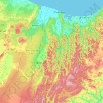
Name: Whakatane District topographic map, elevation, terrain.
Location: Whakatane District, Bay of Plenty, New Zealand (-38.85596 176.47628 -37.82942 177.23950)
Average elevation: 416 m
Minimum elevation: 0 m
Maximum elevation: 1,365 m
Bay of Plenty trails, hiking, mountain biking, running and outdoor activities
Other topographic maps
Click on a map to view its topography, its elevation and its terrain.
Whangamarino
New Zealand > Bay of Plenty > Rotorua Lakes District > Okere Falls
Average elevation: 317 m
Papamoa Hills Regional Park
New Zealand > Bay of Plenty > Western Bay of Plenty District
Average elevation: 53 m
Omokoroa
New Zealand > Bay of Plenty > Western Bay of Plenty District > Omokoroa
Average elevation: 17 m
Waiotapu Village
New Zealand > Bay of Plenty > Rotorua District > Waiotapu Village
Average elevation: 438 m