
Darlington topographic map
Interactive map
Click on the map to display elevation.
About this map
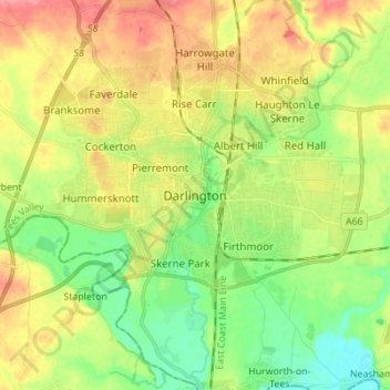
Name: Darlington topographic map, elevation, terrain.
Average elevation: 52 m
Minimum elevation: 21 m
Maximum elevation: 90 m
Other topographic maps
Click on a map to view its topography, its elevation and its terrain.
College of St Hild and St Bede
United Kingdom > England > County Durham > Durham
College of St Hild and St Bede, Claypath, City of Durham, Durham, County Durham, North East, England, United Kingdom
Average elevation: 64 m
Consett
United Kingdom > England > County Durham
Consett, County Durham, North East, England, United Kingdom
Average elevation: 205 m
West Auckland
United Kingdom > England > County Durham
West Auckland, County Durham, North East, England, United Kingdom
Average elevation: 124 m