
Make a donation
Banggi Island topographic map
Click on the map to display elevation.
Make a donation
Banggi Island
Banggi Island (Malay: Pulau Banggi) is located within the Kudat Division of Sabah in Malaysia. With an area of 440.7 square kilometres, it is the largest island in Malaysia followed by Bruit Island, Langkawi Island and Penang Island. It is located off the northern coast of Sabah near Marudu Bay. The highest elevation on the island is Bukit Sinambung with height of 529 metres. As of 2016, it has an estimated population of 30,000. Banggi's largest settlement is Limbuak. In 2014, a new township was proposed to be built in the island. The island is also part of the gazetted area of Tun Mustapha Marine Park.
Make a donation
About this map
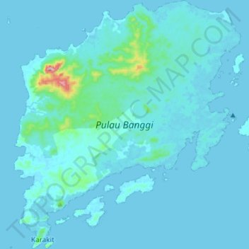
Name: Banggi Island topographic map, elevation, terrain.
Location: Banggi Island, Sabah, Malaysia (7.10037 117.05402 7.36281 117.29496)
Average elevation: 21 m
Minimum elevation: 0 m
Maximum elevation: 487 m
Make a donation
Other topographic maps
Click on a map to view its topography, its elevation and its terrain.
Mount Kinabalu
Mount Kinabalu (Malay: Gunung Kinabalu, Dusun: Gayo Ngaran or Nulu Nabalu) is the highest mountain in Borneo and Malaysia. With an elevation of 13,435 feet (4,095 m), it is third-highest peak of an island on Earth, and 20th most prominent mountain in the world by topographic prominence. The mountain is located…
Average elevation: 3,567 m
Make a donation
Make a donation
Mount Kinabalu
Low's Peak can be climbed by a person in good physical condition without mountaineering equipment on the main route. However, climbers must be accompanied by accredited guides at all times due to national park regulations and the risk of experiencing altitude sickness.
Average elevation: 3,567 m
Make a donation
Make a donation
Make a donation
Make a donation
Make a donation
Make a donation
Make a donation
Make a donation
Mount Kinabalu
Low's Peak can be climbed by a person in good physical condition without mountaineering equipment on the main route. However, climbers must be accompanied by accredited guides at all times due to national park regulations and the risk of experiencing altitude sickness.
Average elevation: 3,567 m
Make a donation
Make a donation
Make a donation
Make a donation
Make a donation
Make a donation
Make a donation
Make a donation
Make a donation
Make a donation