
Thank you for supporting this site ❤️
Make a donation
Make a donation
Mahabang Parang topographic map
Click on the map to display elevation.
Thank you for supporting this site ❤️
Make a donation
Make a donation
About this map
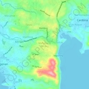
Name: Mahabang Parang topographic map, elevation, terrain.
Location: Mahabang Parang, Rizal, Calabarzon, 1904, Philippines (14.45388 121.19277 14.49388 121.23277)
Average elevation: 43 m
Minimum elevation: -8 m
Maximum elevation: 183 m
Thank you for supporting this site ❤️
Make a donation
Make a donation
Other topographic maps
Click on a map to view its topography, its elevation and its terrain.
Thank you for supporting this site ❤️
Make a donation
Make a donation
Thank you for supporting this site ❤️
Make a donation
Make a donation
Thank you for supporting this site ❤️
Make a donation
Make a donation