
Make a donation
Tianjin topographic map
Click on the map to display elevation.
Make a donation
Tianjin
There is 153 km (95 mi) of coastline and 1,137.48 kilometers (706.80 mi) of land border. It lies at the northern end of the Grand Canal of China, which connects with the Yellow River and Yangtze River. The municipality is generally flat, and swampy near the coast, but hilly in the far north, where the Yan Mountains intrude into northern Tianjin. Extensive tidal flats occur on the coastal plain adjacent to the city. The highest point in the municipality is Jiuding Peak (九顶山) in Ji County on the northern border with Hebei, at an altitude of 1,078.5 m (3,538 ft).
Make a donation
About this map
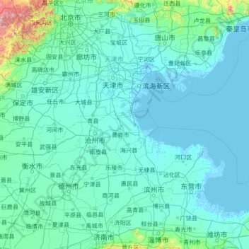
Name: Tianjin topographic map, elevation, terrain.
Location: Tianjin, China (36.56626 113.72998 40.25201 118.05867)
Average elevation: 64 m
Minimum elevation: -4 m
Maximum elevation: 2,561 m
Make a donation
Other topographic maps
Click on a map to view its topography, its elevation and its terrain.
Mount Makalu
China > Tibet > Tingri County
Makalu (Nepali: मकालु हिमाल, romanized: Makālu himāl; Chinese: 马卡鲁峰; pinyin: Mǎkǎlǔ Fēng) is the fifth-highest mountain on Earth, with a summit at an elevation of 8,485 metres (27,838 ft) AMSL. It is located in the Mahalangur Himalayas 19 km (12 mi) southeast of Mount Everest,…
Average elevation: 7,479 m
Make a donation
Turpan Depression
China > Xinjiang > Gaochang District
The Turpan Basin formed in a shear zone during the Late Permian due to motion between the East European and the Angaran craton. It was subsequently deformed by the collision of the Indian and Eurasian plates in the Cenozoic. In the latter deformation, a thrust fault belt running from east to west, the Flaming…
Average elevation: -152 m
Shanghai
The golden age of Shanghai began with its elevation to municipality after it was separated from Jiangsu on 7 July 1927. This new Chinese municipality covered an area of 494.69 km2 (191.0 sq mi), including the modern-day districts of Baoshan, Yangpu, Zhabei, Nanshi, and Pudong, but excluded the foreign…
Average elevation: 5 m
Make a donation
Make a donation
Shanghai
The golden age of Shanghai began with its elevation to municipality after it was separated from Jiangsu on 7 July 1927. This new Chinese municipality covered an area of 494.69 km2 (191.0 sq mi), including the modern-day districts of Baoshan, Yangpu, Zhabei, Nanshi, and Pudong, but excluded the foreign…
Average elevation: 5 m
Make a donation
Golog Tibetan Autonomous Prefecture
China > Qinghai > Maqên County > Dawu
The lay of the land of the prefecture is largely determined by the Amne Machin mountain range (max elevation 6,282 m), which runs in the general northwest- to-southeast direction across the entire prefecture, and beyond. The existence of the ridge results in one of the great bends of the Yellow River, which…
Average elevation: 4,101 m
Make a donation
Make a donation
Golog Tibetan Autonomous Prefecture
China > Qinghai > Gadê County
The lay of the land of the prefecture is largely determined by the Amne Machin mountain range (max elevation 6,282 m), which runs in the general northwest- to-southeast direction across the entire prefecture, and beyond. The existence of the ridge results in one of the great bends of the Yellow River, which…
Average elevation: 4,340 m
Make a donation