
Make a donation
Tyrol topographic map
Click on the map to display elevation.
Make a donation
About this map
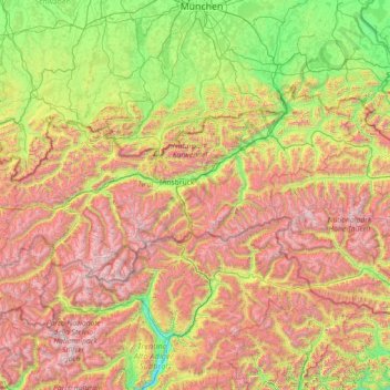
Name: Tyrol topographic map, elevation, terrain.
Location: Tyrol, Austria (46.65136 10.09783 47.74303 12.96600)
Average elevation: 1,410 m
Minimum elevation: 204 m
Maximum elevation: 3,800 m
Make a donation
Other topographic maps
Click on a map to view its topography, its elevation and its terrain.
Make a donation
Make a donation
Turracher Höhe
Austria > Carinthia > Reichenau
The highest point of the approx. two km long pass summit has an altitude of 1,795 m above sea level south of the Turracher Lake. The lake has a water level of 1,763 m above sea (Adria) level and is connected to the village. The Turracher Höhe, as a "classic" pass summit, is also part of a drainage divide…
Average elevation: 1,870 m
Make a donation
Leithaberg
Austria > Burgenland > Bezirk Eisenstadt-Umgebung > Gemeinde Schützen am Gebirge
Average elevation: 319 m
Make a donation
Graz
Austria > Styria > Graz > Graz
Graz is situated on both sides of the Mur river in southeast Austria. It is about 150 km (93 mi) southwest of Vienna (Wien). The nearest larger urban centre is Maribor (Marburg) in Slovenia, which is about 50 km (31 mi) to the south. Graz is the state capital and largest city in Styria, a green and heavily…
Average elevation: 482 m