
Thank you for supporting this site ❤️
Make a donation
Make a donation
Pine Mountain topographic map
Click on the map to display elevation.
Thank you for supporting this site ❤️
Make a donation
Make a donation
About this map
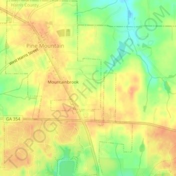
Name: Pine Mountain topographic map, elevation, terrain.
Location: Pine Mountain, Harris County, Georgia, United States (32.84279 -84.86202 32.87255 -84.83838)
Average elevation: 274 m
Minimum elevation: 249 m
Maximum elevation: 287 m
Thank you for supporting this site ❤️
Make a donation
Make a donation
Other topographic maps
Click on a map to view its topography, its elevation and its terrain.
Thank you for supporting this site ❤️
Make a donation
Make a donation
Thank you for supporting this site ❤️
Make a donation
Make a donation
Thank you for supporting this site ❤️
Make a donation
Make a donation