
Genesee County topographic map
Interactive map
Click on the map to display elevation.
About this map
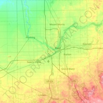
Name: Genesee County topographic map, elevation, terrain.
Location: Genesee County, Michigan, United States (42.78077 -83.93207 43.22312 -83.45330)
Average elevation: 246 m
Minimum elevation: 184 m
Maximum elevation: 370 m
Other topographic maps
Click on a map to view its topography, its elevation and its terrain.
Detroit
United States > Michigan > Wayne County
Detroit, Wayne County, Michigan, United States
Average elevation: 187 m
Flint
United States > Michigan > Genesee County
Flint, Genesee County, Michigan, United States
Average elevation: 236 m
Grand Rapids
United States > Michigan > Kent County
Grand Rapids, Kent County, Michigan, United States
Average elevation: 216 m
South Haven Charter Township
United States > Michigan > Van Buren County
South Haven Charter Township, Van Buren County, Michigan, 49090, United States
Average elevation: 191 m
Fennville
United States > Michigan > Allegan County
Fennville, Allegan County, Michigan, United States
Average elevation: 204 m
Clarksville
United States > Michigan > Ionia County
Clarksville, Campbell Township, Ionia County, Michigan, United States
Average elevation: 255 m
Perry Lake Heights
United States > Michigan > Oakland County
Perry Lake Heights, Oakland County, Michigan, 48462, United States
Average elevation: 317 m
Churchill Township
United States > Michigan > Ogemaw County
Churchill Township, Ogemaw County, Michigan, United States
Average elevation: 265 m
Redford Charter Township
United States > Michigan > Wayne County
Redford Charter Township, Wayne County, Michigan, 48239, United States
Average elevation: 195 m
Commerce Charter Township
United States > Michigan > Oakland County
Commerce Charter Township, Oakland County, Michigan, 48382, United States
Average elevation: 287 m
Roscommon County
Roscommon County, Michigan, United States
Average elevation: 356 m
Hawks
United States > Michigan > Hawks
Hawks, Bismark Township, Presque Isle County, Michigan, 49743, United States
Average elevation: 250 m
Pontiac
United States > Michigan > Pontiac
Pontiac, Oakland County, Michigan, United States
Average elevation: 290 m
Pellston
United States > Michigan > Pellston
Pellston, McKinley Township, Emmet County, Michigan, United States
Average elevation: 212 m
Westland
United States > Michigan > Westland
Westland, Wayne County, Michigan, United States
Average elevation: 202 m
Pinconning Township
Pinconning Township, Bay County, Michigan, 48650, United States
Average elevation: 185 m
Croswell
United States > Michigan > Croswell
Croswell, Sanilac County, Michigan, United States
Average elevation: 226 m
Plymouth
United States > Michigan > Plymouth
Plymouth, Wayne County, Michigan, 48170, United States
Average elevation: 223 m
East Lansing
United States > Michigan > Ingham County
East Lansing, Ingham County, Michigan, United States
Average elevation: 261 m
Marquette County
Marquette County, Michigan, United States
Average elevation: 332 m