
Thank you for supporting this site ❤️
Make a donation
Make a donation
Marawi topographic map
Click on the map to display elevation.
Thank you for supporting this site ❤️
Make a donation
Make a donation
Marawi
Marawi is located upon the shores of Lake Lanao. It is primarily inhabited by the Maranao people. The city is also called the "summer capital of the south" due to its higher elevation and cooler climate, a nickname it shares with Malaybalay.
Thank you for supporting this site ❤️
Make a donation
Make a donation
About this map
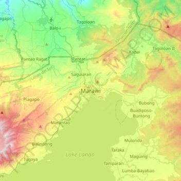
Name: Marawi topographic map, elevation, terrain.
Location: Marawi, Lanao del Sur, Bangsamoro, 9700, Philippines (7.84473 124.12544 8.16473 124.44544)
Average elevation: 707 m
Minimum elevation: 78 m
Maximum elevation: 1,798 m
Thank you for supporting this site ❤️
Make a donation
Make a donation
Other topographic maps
Click on a map to view its topography, its elevation and its terrain.