
Thank you for supporting this site ❤️
Make a donation
Make a donation
Puhoi topographic map
Click on the map to display elevation.
Thank you for supporting this site ❤️
Make a donation
Make a donation
About this map
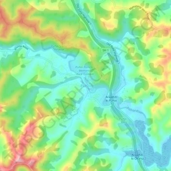
Name: Puhoi topographic map, elevation, terrain.
Location: Puhoi, Rodney, Auckland, 0951, New Zealand (-36.53209 174.64112 -36.49209 174.68112)
Average elevation: 62 m
Minimum elevation: 0 m
Maximum elevation: 180 m
Auckland trails, hiking, mountain biking, running and outdoor activities
Thank you for supporting this site ❤️
Make a donation
Make a donation
Other topographic maps
Click on a map to view its topography, its elevation and its terrain.