
Tāwharanui Regional Park topographic map
Click on the map to display elevation.
About this map
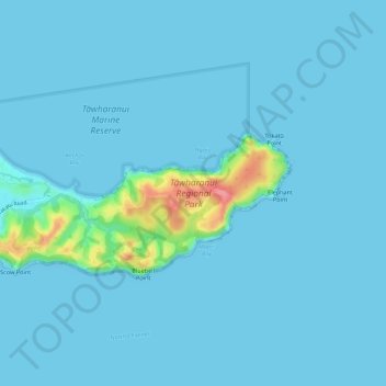
Name: Tāwharanui Regional Park topographic map, elevation, terrain.
Location: Tāwharanui Regional Park, Rodney, Auckland, New Zealand (-36.37933 174.81340 -36.35919 174.86838)
Average elevation: 7 m
Minimum elevation: 0 m
Maximum elevation: 88 m
Auckland trails, hiking, mountain biking, running and outdoor activities
Other topographic maps
Click on a map to view its topography, its elevation and its terrain.