
Paremoremo Creek topographic map
Interactive map
Click on the map to display elevation.
About this map
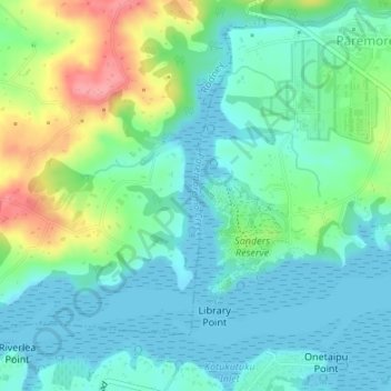
Name: Paremoremo Creek topographic map, elevation, terrain.
Location: Paremoremo Creek, Rodney, Auckland, 0793, New Zealand (-36.76995 174.63282 -36.75796 174.63424)
Average elevation: 28 m
Minimum elevation: -2 m
Maximum elevation: 101 m
Auckland trails, hiking, mountain biking, running and outdoor activities
Other topographic maps
Click on a map to view its topography, its elevation and its terrain.